 Filter: Categories of Wisconsin Historical Images
Filter: Subject of Dams
Filter: Creator Name of Unknown
Filter: Categories of Wisconsin Historical Images
Filter: Subject of Dams
Filter: Creator Name of Unknown

| Date: | 1909 |
|---|---|
| Description: | This 1909 map of Taylor County, Wisconsin, shows the township and range grid, towns, sections, cities and villages, settlers houses, schools, churches, saw... |

| Date: | 1900 |
|---|---|
| Description: | Shows limits of drainage basin, dams, rapids, roads, and railroads in parts of Iron and Vilas Counties, Wisconsin. From the E.P. Sherry papers relating to ... |

| Date: | 1932 |
|---|---|
| Description: | View from shoreline of a pond that has formed behind a beaver dam. |
| Date: | 1935 |
|---|---|
| Description: | Five women pose at the dam built by Frank Lloyd Wright at his home near Spring Green, Wisconsin. A sixth figure is obscured by tree branches on the right. ... |
| Date: | |
|---|---|
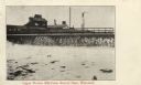
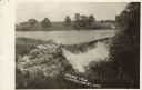
| Description: | Postcard view of a dam with a mill behind it. Caption reads: "Upper Woolen Mill Dam, Beaver Dam, Wisconsin." |
| Date: | |
|---|---|
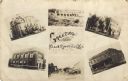
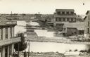
| Description: | Photographic collage of six views of Black River Falls, featuring the Grade School, High School, Bank, Main Street, a commercial business block and the da... |
| Date: | 1890 |
|---|---|
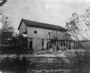
| Description: | Herling Saw Mill and Dam Southeast elevation. |
| Date: | 1910 |
|---|---|
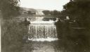
| Description: | View of a river with a dam waterfall. A road runs along the far side of the river, and a large barn is across the road on the right. Caption reads: "Scenic... |

| Date: | 1915 |
|---|---|
| Description: | Little Eau Pleine river in flood season, with the water rushing over a small dam. |
| Date: | 1922 |
|---|---|
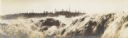
| Description: | Semi-panoramic view of rapids, water pouring near the dam of the Great Northern Paper Company. |
| Date: | |
|---|---|
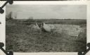
| Description: | The Civilian Conservation Corps dam built at Camp Petenwell near Necedah. |

| Date: | 1846 |
|---|---|
| Description: | This plat map, which features the very early spelling of Wisconsin as "Wiskonsin", was created sometime between 1846 and 1854 and shows a canal and dam on ... |

| Date: | 1920 |
|---|---|
| Description: | Color-enhanced postcard with an elevated view of the dam and swing bridge over the lock on the Fox River. Caption reads: "Birdseye View of Dam and Bridge o... |
| Date: | 1910 |
|---|---|
| Description: | Photographic postcard of elevated view of the back of mills lining the bridge. Coal kilns are below the hand-drawn arrow at top right. "Sawmills, gristmill... |
| Date: | 1910 |
|---|---|
| Description: | View from opposite shoreline through trees toward the Glen Loch dam and mill in Irvine Park. Caption reads: "Old Mill, Glen Loch, Irvine Park, Chippewa Fal... |
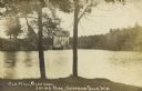
| Date: | 1910 |
|---|---|
| Description: | Colored photographic postcard view of the dells below the dam on the Chippewa river. There is a boardwalk at the base of the cliff leading to the dam. Capt... |

| Date: | 11 15 1957 |
|---|---|
| Description: | This map shows single family residence district, business district, and manufacturing district, as well as block and lot numbers, Hustis Homestead, gravel ... |

| Date: | 1910 |
|---|---|
| Description: | This blue print map shows original lakes, area to be covered by Chippewa Flowage (flow-lines for contours 1310 and 1315), dam sites, roads, and buildings. |

| Date: | 1975 |
|---|---|
| Description: | This map shows nature trails, public attractions, public hunting and fishing grounds, dams, waysides, lakes, highways, and roads. The upper right corner in... |

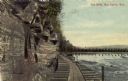
| Date: | |
|---|---|
| Description: | View of the dam at the Dells of the Chippewa River. The paper mill is in the background on the opposite shoreline. Caption reads: "Dells Dam and Paper Mill... |
If you didn't find the material you searched for, our Library Reference Staff can help.
Call our reference desk at 608-264-6535 or email us at: