 Filter: Categories of Wisconsin Historical Images
Filter: Subject of Farmhouses
Filter: Subject of farms
Filter: Subject of bridges
Filter: Categories of Wisconsin Historical Images
Filter: Subject of Farmhouses
Filter: Subject of farms
Filter: Subject of bridges
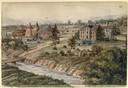
| Date: | 1858 |
|---|---|
| Description: | Hölzlhuber located this farm at about three German miles from Stevens Point. The region's soil was quite fertile. A wooden dwelling house stood in the mids... |
| Date: | |
|---|---|
| Description: | Elevated view of barn and farmer's house of John Bass. |
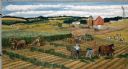
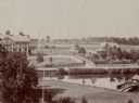
| Date: | 1980 |
|---|---|
| Description: | Farmers work cooperatively with their horse teams on silo-filling activities early in autumn. Rows of green forage are created in the fields and carried to... |

| Date: | |
|---|---|
| Description: | Colorized postcard of the horseshoe curve of railroad tracks. Elevated view of the railroad tracks with train snaking past a farmhouse and a bridge suspend... |
| Date: | |
|---|---|
| Description: | Elevated view of farmland. In the bottom-left center, there is a structure with a bell tower near a dirt road. In the center there is a similar building. T... |

| Date: | 1902 |
|---|---|
| Description: | This 1902 map of the eastern portion of Sawyer County, Wisconsin, shows the township and range system, sections, roads, farm houses, camps, school houses, ... |

| Date: | 1913 |
|---|---|
| Description: | View from riverbank looking down towards two girls standing in the middle of a bridge along a road. They are looking over the railing at the water below. F... |

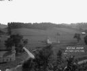
| Date: | 05 06 1929 |
|---|---|
| Description: | View of country road, bridge and farm buildings. |
If you didn't find the material you searched for, our Library Reference Staff can help.
Call our reference desk at 608-264-6535 or email us at: