 Filter: Categories of Wisconsin Historical Images
Filter: Subject of Farmhouses
Filter: Subject of roads
Filter: Subject of water
Filter: Categories of Wisconsin Historical Images
Filter: Subject of Farmhouses
Filter: Subject of roads
Filter: Subject of water
| Date: | |
|---|---|
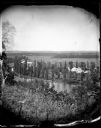
| Description: | View from hill over a valley dotted with farmsteads and a meandering stream in the foreground. A group of three or four people are posing at the opposite s... |
| Date: | |
|---|---|
| Description: | Elevated view of barn and farmer's house of John Bass. |

| Date: | |
|---|---|
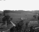
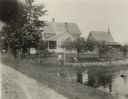
| Description: | View of a country farmhouse and rural road. A covered bridge and dam can be seen nearby. Text on photograph reads: "N.H. McQuiston & Son." |
| Date: | |
|---|---|
| Description: | View looking north from a covered bridge, including a rocky stream-bed and a tree-lined dirt road with houses and other wooden buildings. Caption reads, "V... |
| Date: | |
|---|---|
| Description: | Elevated view of farmland. In the bottom-left center, there is a structure with a bell tower near a dirt road. In the center there is a similar building. T... |
| Date: | 09 09 1922 |
|---|---|
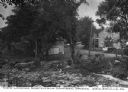
| Description: | The farmhouse of the Wetherby Cranberry Company. At the time the farmhouse was owned by H. Kissinger. In the foreground is the corner of the water reservoi... |

| Date: | 1944 |
|---|---|
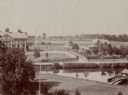
| Description: | Continental Transportation Lines, Inc. operating an International truck tractor on an urban highway. A bridge, houses and industrial buildings are in the b... |

| Date: | 1897 |
|---|---|
| Description: | This 1897 map of Sawyer County, Wisconsin, shows the township and range system, sections, roads, farm houses, camps, school houses, dams, bridges, Indian r... |

| Date: | 1902 |
|---|---|
| Description: | This 1902 map of the eastern portion of Sawyer County, Wisconsin, shows the township and range system, sections, roads, farm houses, camps, school houses, ... |

| Date: | 1919 |
|---|---|
| Description: | This 1919 map of Sawyer County, Wisconsin, shows the township and range system, sections, cities and villages, roads, railroads, farm houses, the Indian re... |
| Date: | |
|---|---|
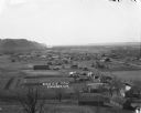
| Description: | View down hill towards Stoddard, with the Mississippi River and hills in the background. The German Lutheran Church is in the foreground, and there are rai... |

| Date: | 1857 |
|---|---|
| Description: | Map of La Crosse County, Wisconsin showing village plat, farm houses, schools, roads, railroads, township names (New Amsterdam, Dacota, Minnesota, Driesbac... |

| Date: | 1913 |
|---|---|
| Description: | View from riverbank looking down towards two girls standing in the middle of a bridge along a road. They are looking over the railing at the water below. F... |

| Date: | 1927 |
|---|---|
| Description: | This Blue line print map shows trade area boundaries, lakes, farm homes, railways, high schools, public highways, and townships. A symbol key is included i... |
If you didn't find the material you searched for, our Library Reference Staff can help.
Call our reference desk at 608-264-6535 or email us at: