 Filter: Categories of Wisconsin Historical Images
Filter: Subject of Farmhouses
Filter: Subject of water
Filter: Creator Name of Unknown
Filter: Categories of Wisconsin Historical Images
Filter: Subject of Farmhouses
Filter: Subject of water
Filter: Creator Name of Unknown
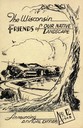
| Date: | 1948 |
|---|---|
| Description: | Cover for the 1948 Wisconsin Friends of Our Native Landscape program. Depicted is a sketch of a tree, a fence, and a small town by a lake. The Wisconsin Fr... |
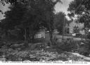
| Date: | |
|---|---|
| Description: | Elevated view of barn and farmer's house of John Bass. |

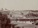
| Date: | |
|---|---|
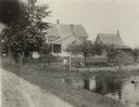
| Description: | Elevated view of mill pond and homes along the opposite shoreline. A person is standing at the shoreline in the foreground. Caption reads, "Mill Pond, Mill... |
| Date: | |
|---|---|
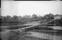
| Description: | View looking north from a covered bridge, including a rocky stream-bed and a tree-lined dirt road with houses and other wooden buildings. Caption reads, "V... |

| Date: | |
|---|---|
| Description: | Colorized postcard of the horseshoe curve of railroad tracks. Elevated view of the railroad tracks with train snaking past a farmhouse and a bridge suspend... |
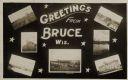
| Date: | 05 15 1909 |
|---|---|
| Description: | Photographic postcard of a poster promoting Bruce with seven photographs. The fairgrounds, Main Street, farm scene, Catholic Church, Chippewa River bridge,... |
| Date: | 09 09 1922 |
|---|---|
| Description: | The farmhouse of the Wetherby Cranberry Company. At the time the farmhouse was owned by H. Kissinger. In the foreground is the corner of the water reservoi... |

| Date: | 1897 |
|---|---|
| Description: | This 1897 map of Sawyer County, Wisconsin, shows the township and range system, sections, roads, farm houses, camps, school houses, dams, bridges, Indian r... |

| Date: | 1902 |
|---|---|
| Description: | This 1902 map of the eastern portion of Sawyer County, Wisconsin, shows the township and range system, sections, roads, farm houses, camps, school houses, ... |
| Date: | 1918 |
|---|---|
| Description: | View looking down low hill towards a narrow footbridge which crosses a small river to a village composed of wooden buildings with wooden fences. On the rig... |
| Date: | 1918 |
|---|---|
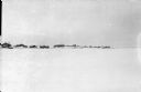
| Description: | View across what is probably a frozen river covered with snow towards a village surrounded by a fence north of the Pinega settlement in northern Russia. |

| Date: | |
|---|---|
| Description: | Colorized elevated view of a Norwegian rural home. The buildings in the foreground are the home of Lars Haagenson. Across the Glomma River is the Aaseth Es... |

| Date: | 09 01 1919 |
|---|---|
| Description: | Photographic postcard view of a river, with part of an outbuilding in the foreground on the left. On the opposite shoreline is a farm, with farmhouse, barn... |
If you didn't find the material you searched for, our Library Reference Staff can help.
Call our reference desk at 608-264-6535 or email us at: