Filter: Categories of Wisconsin Historical Images
Filter: Subject of Fields (Agriculture)
Filter: Subject of dwellings
Filter: Subject of church buildings
Filter: Categories of Wisconsin Historical Images
Filter: Subject of Fields (Agriculture)
Filter: Subject of dwellings
Filter: Subject of church buildings

| Date: | 1874 |
|---|---|
| Description: | Bird's-eye map of Chippewa Falls. |

| Date: | 1881 |
|---|---|
| Description: | Bird's-eye map of Milton Junction. |
| Date: | |
|---|---|
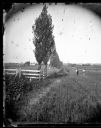
| Description: | A rural lane lined with Lombardy poplars runs between two fenced fields. Two men are standing in the lane looking towards the camera. A church and many oth... |

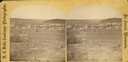
| Date: | 1874 |
|---|---|
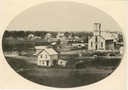
| Description: | Distant view of the town from a hill with houses, garden plots, businesses and churches. |
| Date: | 1874 |
|---|---|
| Description: | View of New Glarus from a neighboring hill. A man, wearing a hat and suit, and five children, girls and boys, are posing along the fence in the foreground.... |
| Date: | 1876 |
|---|---|
| Description: | A view of the town of Lodi as viewed from the hill north of the cemetery. |
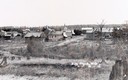
| Date: | 1900 |
|---|---|
| Description: | View from hill across field towards farmhouses, dwellings and churches along a road. In the foreground are stumps. Caption reads: "Big Falls, Wis." |
| Date: | 1928 |
|---|---|
| Description: | View from hill of uptown Cross Plains with the Catholic Church (St. Francis Xavier) and farmhouses. |

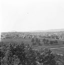
| Date: | 10 1928 |
|---|---|
| Description: | Aerial view of Sun Prairie, including the central business district, residences, and the surrounding countryside stretching to the horizon. |
| Date: | 1912 |
|---|---|
| Description: | Elevated view of Wausau from the edge of town looking toward residences and businesses. Hills are in the far background. |

| Date: | 1910 |
|---|---|
| Description: | Elevated view of the First Presbyterian church and two mansions. The Mahoning river and a park is in the foreground, and other parts of the town stretch in... |
| Date: | |
|---|---|
| Description: | View of Lovers Lane, which a dirt road with a sidewalk and bridge on the right. There are power lines in the foreground, and a town in the background. Ther... |

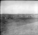
| Date: | |
|---|---|
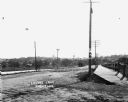
| Description: | Elevated view of the town with hills in the distance. In the foreground are cattle inside a fence near a cemetery with a windmill. The town is behind furth... |
| Date: | |
|---|---|
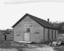
| Description: | Exterior of the one-room United Brethren [?] Church. There is an outhouse to the left of the church. On the right is a hill with trees. Farm building and a... |
| Date: | 1916 |
|---|---|
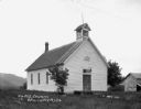
| Description: | Exterior view of the Methodist Evangelical Church. The building features a sign that says: M.E. 1893. There is a lamp over the entrance, a small, lattice-e... |
| Date: | 1916 |
|---|---|
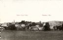
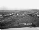
| Description: | Bird's-eye view of town. Fields, with farms and fences, surround the town made up of numerous dwellings and a church. |

| Date: | |
|---|---|
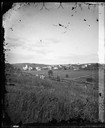
| Description: | View from a hilltop looking down at the village. On the hilltop, there is a small tree. In the village are homes, a church, shops, and in the far distance,... |

| Date: | 1913 |
|---|---|
| Description: | View of the village during the winter. There are many homes, shops, several churches and open land. Many of the buildings are two stories high. |
If you didn't find the material you searched for, our Library Reference Staff can help.
Call our reference desk at 608-264-6535 or email us at: