 Filter: Categories of Wisconsin Historical Images
Filter: Subject of Fields (Agriculture)
Filter: Subject of farms
Filter: Subject of forests and forestry
Filter: Categories of Wisconsin Historical Images
Filter: Subject of Fields (Agriculture)
Filter: Subject of farms
Filter: Subject of forests and forestry

| Date: | 03 24 1913 |
|---|---|
| Description: | Picnic Point from the University Farm fields, now known as Observatory Hill. |
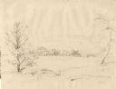
| Date: | 1852 |
|---|---|
| Description: | Rural landscape with farm buildings seen from across a field and framed by trees. |
| Date: | 1930 |
|---|---|
| Description: | View from hill of a farm near a pond. There are homes along the far shoreline, and a lake and hills in the far background. |
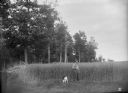
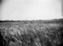
| Date: | 07 19 1895 |
|---|---|
| Description: | Man and dog standing in a field of spring wheat on the farm of Ferdinand Ledke. Another man is standing in the background, facing the forest. |
| Date: | 08 02 1895 |
|---|---|
| Description: | Two men stand waist-high in the cabbage, pea, and oat fields of the C.C. Washburn homestead, twelve miles southwest of Florence. Wooden houses or outbuildi... |

| Date: | 07 30 1895 |
|---|---|
| Description: | Two men stand in the five-foot tall pea field of Joseph Seipold three miles northeast of Antigo. Another man stands atop a horse-drawn wagon loaded with ha... |
| Date: | 07 09 1895 |
|---|---|
| Description: | A twenty-acre field of barley on the farm of Chas Parey, with two men standing waist-high in the barley. A hardwood forest lines the edge of the field in t... |

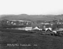
| Date: | |
|---|---|
| Description: | Elevated view from hill of farmhouse, farm buildings, and fenced yards. People are posing standing near the bottom of the hill behind a fence in the center... |

| Date: | 1895 |
|---|---|
| Description: | Two women, a man and a child posing on a road adjoining their homestead, with stumpland and a forest behind them. |

| Date: | 03 1777 |
|---|---|
| Description: | Map showing the British and Hessian attack on Fort Washington in November of 1776. The movements and fortifications of the British and Hessian troops appea... |

| Date: | 1776 |
|---|---|
| Description: | Fairly detailed map of New York City and parts of Long Island. It shows streets, roads, wharves, ferries, ship yards, Fort George and the battery, public b... |

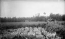
| Date: | 09 11 1960 |
|---|---|
| Description: | Slightly elevated view across fields and small patches of woodlands. A barn is on a hill in the distance, and there are cows in a field below on the right.... |
If you didn't find the material you searched for, our Library Reference Staff can help.
Call our reference desk at 608-264-6535 or email us at: