Filter: Categories of Wisconsin Historical Images
Filter: Subject of Fields (Agriculture)
Filter: Subject of farms
Filter: Subject of rivers
Filter: Categories of Wisconsin Historical Images
Filter: Subject of Fields (Agriculture)
Filter: Subject of farms
Filter: Subject of rivers
| Date: | |
|---|---|
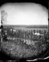
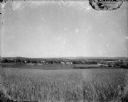
| Description: | View from hill over a valley dotted with farmsteads and a meandering stream in the foreground. A group of three or four people are posing at the opposite s... |
| Date: | 1875 |
|---|---|
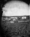
| Description: | View, through a cornfield, of people, a store, a sawmill and wagons. Moscow was platted in 1850 by an Englishman, Chauncy Smith, who dammed the Bluemound ... |
| Date: | 1900 |
|---|---|
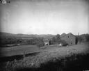
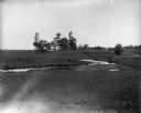
| Description: | Rural scene of farmstead with a river or stream (?) in the background. The farm is bounded by a barbed wire fence, and there is a utility pole on the bank ... |

| Date: | 1914 |
|---|---|
| Description: | Slightly elevated view of a man driving three women in an International Model M truck along a rural road. In the background is a valley with farm buildings... |
| Date: | 1920 |
|---|---|
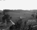
| Description: | A view of a rolling rural landscape, most likely in Sauk County. In the far distance are houses and farm buildings, a church and a larger building, center ... |

| Date: | 1900 |
|---|---|
| Description: | Three men use a McCormick grain binder in a field overlooking a body of water, probably the Saint John River, in Fredericton, New Brunswick, Canada. Men an... |

| Date: | |
|---|---|
| Description: | Colorized postcard of the horseshoe curve of railroad tracks. Elevated view of the railroad tracks with train snaking past a farmhouse and a bridge suspend... |
| Date: | |
|---|---|
| Description: | The Richardson Farm stands at the far edge of a farm field with a creek running through it and animals grazing. The farmhouse is white and surrounded by tr... |
| Date: | |
|---|---|
| Description: | Elevated view of farmland. In the bottom-left center, there is a structure with a bell tower near a dirt road. In the center there is a similar building. T... |

| Date: | 1913 |
|---|---|
| Description: | View from riverbank looking down towards two girls standing in the middle of a bridge along a road. They are looking over the railing at the water below. F... |

| Date: | 1900 |
|---|---|
| Description: | View from hill looking down towards valley with fields and a river. |

| Date: | 03 1777 |
|---|---|
| Description: | Map showing the British and Hessian attack on Fort Washington in November of 1776. The movements and fortifications of the British and Hessian troops appea... |

| Date: | 1776 |
|---|---|
| Description: | Fairly detailed map of New York City and parts of Long Island. It shows streets, roads, wharves, ferries, ship yards, Fort George and the battery, public b... |

| Date: | 1921 |
|---|---|
| Description: | View across field towards a bend in the Shullsburg Branch, which runs from the Galena River near the town of Lead Mine to the town of Shullsburg. A farm is... |

| Date: | 09 01 1919 |
|---|---|
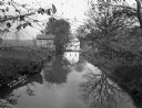
| Description: | Photographic postcard view of a river, with part of an outbuilding in the foreground on the left. On the opposite shoreline is a farm, with farmhouse, barn... |
| Date: | |
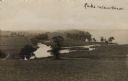
|---|---|
| Description: | View of Lake Waubesa from a hill. A farm is in the distance on the left. The Yahara River is in the foreground. Handwritten caption reads: "Lake Waubesa." |
If you didn't find the material you searched for, our Library Reference Staff can help.
Call our reference desk at 608-264-6535 or email us at: