 Filter: Categories of Wisconsin Historical Images
Filter: Subject of Fields (Agriculture)
Filter: Subject of forests and forestry
Filter: Subject of cities and towns
Filter: Categories of Wisconsin Historical Images
Filter: Subject of Fields (Agriculture)
Filter: Subject of forests and forestry
Filter: Subject of cities and towns

| Date: | 1883 |
|---|---|
| Description: | Bird's-eye map of Sauk City. |
| Date: | |
|---|---|
| Description: | Elevated view of country town showing large. There are wooden buildings alongside the Delaware River which curves through fields and patches of woods in th... |
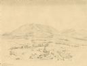
| Date: | 1852 |
|---|---|
| Description: | Landscape featuring a rural city center with a prominent courthouse surrounded by fields and woods. Rolling erosion-softened mountains rise in the backgro... |

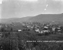
| Date: | 1925 |
|---|---|
| Description: | Elevated view of Coon Valley from a hilltop. Trees are on either side of the frame. In the city, there is a cemetery, church, and field of crops. |
| Date: | 1925 |
|---|---|
| Description: | View of Coon Valley. Tall plants cover the lower portion of the frame. The landscape is includes homes, fields, and hills. |

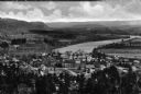
| Date: | 1915 |
|---|---|
| Description: | Elevated view of an urban main street in the foreground and a rural landscape in the background. |

| Date: | 1950 |
|---|---|
| Description: | Aerial view of town, showing all of Lake Metonga in the background. Caption reads: "Greetings from Crandon, Wisconsin." |

| Date: | 1831 |
|---|---|
| Description: | This map shows the land that makes up Michigan, Wisconsin, Minnesota, Indiana, and parts of Canada. The Great Lakes are displayed prominently, along with s... |

| Date: | 1970 |
|---|---|
| Description: | This map shows colored-coded land use with a legend in the bottom margin. Land classifications include: Year-round Residential (yellow), Seasonal Residenti... |

| Date: | 03 1777 |
|---|---|
| Description: | Map showing the British and Hessian attack on Fort Washington in November of 1776. The movements and fortifications of the British and Hessian troops appea... |

| Date: | 1776 |
|---|---|
| Description: | Fairly detailed map of New York City and parts of Long Island. It shows streets, roads, wharves, ferries, ship yards, Fort George and the battery, public b... |

| Date: | 1950 |
|---|---|
| Description: | Text on front reads: "Horseshoe Curve At Rock Springs, Wis." A road and a railroad track, with bridges over the Baraboo River, make a double curve in an el... |
If you didn't find the material you searched for, our Library Reference Staff can help.
Call our reference desk at 608-264-6535 or email us at: