 Filter: Categories of Wisconsin Historical Images
Filter: Subject of Fields (Agriculture)
Filter: Subject of forests and forestry
Filter: Subject of hills
Filter: Categories of Wisconsin Historical Images
Filter: Subject of Fields (Agriculture)
Filter: Subject of forests and forestry
Filter: Subject of hills

| Date: | 03 24 1913 |
|---|---|
| Description: | Picnic Point from the University Farm fields, now known as Observatory Hill. |
| Date: | |
|---|---|
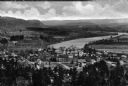
| Description: | Elevated view of country town showing large. There are wooden buildings alongside the Delaware River which curves through fields and patches of woods in th... |

| Date: | 1925 |
|---|---|
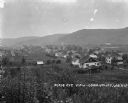
| Description: | Elevated view of Coon Valley from a hilltop. Trees are on either side of the frame. In the city, there is a cemetery, church, and field of crops. |
| Date: | 1925 |
|---|---|
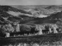
| Description: | View of Coon Valley. Tall plants cover the lower portion of the frame. The landscape is includes homes, fields, and hills. |

| Date: | |
|---|---|
| Description: | Elevated view from hill of farmhouse, farm buildings, and fenced yards. People are posing standing near the bottom of the hill behind a fence in the center... |

| Date: | |
|---|---|
| Description: | View of a forest fire taken from an adjoining field. A fence separates the field from the burning trees. |

| Date: | 10 28 1936 |
|---|---|
| Description: | Outdoor group portrait of the state foresters at a meeting of the National Association of State Foresters in Wisconsin, October 28-30th. |

| Date: | 03 1777 |
|---|---|
| Description: | Map showing the British and Hessian attack on Fort Washington in November of 1776. The movements and fortifications of the British and Hessian troops appea... |
| Date: | 1953 |
|---|---|
| Description: | Elevated view along a hillside into a valley, with forests, buildings, and crop fields. Caption reads: "Barree Coulee from St. Joseph's Ridge, La Crosse Co... |
| Date: | 07 1964 |
|---|---|
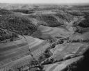
| Description: | Aerial view of fields along hills, surrounded by forests. There are roads and buildings, and hay bales in the field. |

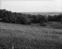
| Date: | 06 04 1961 |
|---|---|
| Description: | View across a field, with a gently sloping hill to the left, and hills and forests in the distance. Caption reads: "Denzer (vicinity), Wis. June 4, 1961. F... |

| Date: | 09 11 1960 |
|---|---|
| Description: | Slightly elevated view across fields and small patches of woodlands. A barn is on a hill in the distance, and there are cows in a field below on the right.... |
| Date: | 06 28 1964 |
|---|---|
| Description: | View across a field sloping down toward a woodland area, with fields and hills in the distance. Caption reads: "Primrose (vicinity), Wis. June 28, 1960. Bi... |

| Date: | 1950 |
|---|---|
| Description: | Text on front reads: "Horseshoe Curve At Rock Springs, Wis." A road and a railroad track, with bridges over the Baraboo River, make a double curve in an el... |
If you didn't find the material you searched for, our Library Reference Staff can help.
Call our reference desk at 608-264-6535 or email us at: