 Filter: Categories of Wisconsin Historical Images
Filter: Subject of Fields (Agriculture)
Filter: Subject of hills
Filter: Subject of orchards
Filter: Categories of Wisconsin Historical Images
Filter: Subject of Fields (Agriculture)
Filter: Subject of hills
Filter: Subject of orchards
| Date: | |
|---|---|
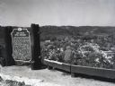
| Description: | Image of the historical marker for Gays Mills Apple Orchards overlooking the town of Gays Mills, Wisconsin. The marker stands to the left, leaving an eleva... |
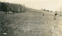
| Date: | 05 1911 |
|---|---|
| Description: | Stone walls line a tilled field where workers carry shovels and bundles of small trees to plant an orchard. |

| Date: | 1922 |
|---|---|
| Description: | View from hill of cherry trees in bloom in the Gibraltar Orchard on Sturgeon Bay Road (Highway 42.) |

| Date: | 03 1777 |
|---|---|
| Description: | Map showing the British and Hessian attack on Fort Washington in November of 1776. The movements and fortifications of the British and Hessian troops appea... |
If you didn't find the material you searched for, our Library Reference Staff can help.
Call our reference desk at 608-264-6535 or email us at: