 Filter: Categories of Wisconsin Historical Images
Filter: Subject of Fields (Agriculture)
Filter: Subject of orchards
Filter: Subject of human settlements
Filter: Categories of Wisconsin Historical Images
Filter: Subject of Fields (Agriculture)
Filter: Subject of orchards
Filter: Subject of human settlements
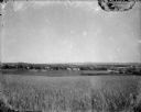
| Date: | 1920 |
|---|---|
| Description: | A view of a rolling rural landscape, most likely in Sauk County. In the far distance are houses and farm buildings, a church and a larger building, center ... |
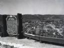
| Date: | |
|---|---|
| Description: | Image of the historical marker for Gays Mills Apple Orchards overlooking the town of Gays Mills, Wisconsin. The marker stands to the left, leaving an eleva... |

| Date: | 03 1777 |
|---|---|
| Description: | Map showing the British and Hessian attack on Fort Washington in November of 1776. The movements and fortifications of the British and Hessian troops appea... |

| Date: | 1958 |
|---|---|
| Description: | Small stone structure next to a field, with a flowering tree in the foreground. Trees, a fence, farm buildings and a silo are in the background. |
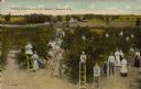
| Date: | 1910 |
|---|---|
| Description: | Text on front reads: "Picking Cherries at N.C. Jacobs', Sawyer, Wis." An elevated view of a group of women, men and children picking cherries using ladders... |
If you didn't find the material you searched for, our Library Reference Staff can help.
Call our reference desk at 608-264-6535 or email us at: