Filter: Categories of Wisconsin Historical Images
Filter: Subject of Fields (Agriculture)
Filter: Subject of roads
Filter: Creator Name of Unknown
Filter: Categories of Wisconsin Historical Images
Filter: Subject of Fields (Agriculture)
Filter: Subject of roads
Filter: Creator Name of Unknown

| Date: | 1905 |
|---|---|
| Description: | Aerial view of town, with several large buildings along railroad tracks in the foreground, and fields and trees in the distance. Pedestrians are walking al... |
| Date: | 07 15 1925 |
|---|---|
| Description: | Natesta cabin site in Clinton. View down road, with a fence on the right, and fields on both sides. |
| Date: | 1860 |
|---|---|
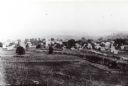
| Description: | Elevated view of multiple buildings in Cross Plains from Lutheran Church Hill. Many roads and fences cross the fields. Wooded hills are in the background. ... |
| Date: | |
|---|---|
| Description: | Elevated view of barn and farmer's house of John Bass. |

| Date: | 1965 |
|---|---|
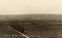
| Description: | Aerial view of town and Highway 66. |

| Date: | 1910 |
|---|---|
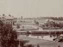
| Description: | View across field toward the hospital. Caption reads: "St. Vincent Hospital, Green Bay, Wis." |
| Date: | 1908 |
|---|---|
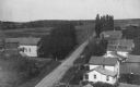
| Description: | Elevated view of homes alongside a road in Hika (also known as Centerville). Handwritten on two of the buildings on the right are: "Ma's house." and "Louis... |

| Date: | 1900 |
|---|---|
| Description: | Elevated view of La Crosse. Caption reads: "Panorama of La Crosse, Wis. from Grand Dad's Bluff." |
| Date: | 1965 |
|---|---|
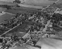
| Description: | Aerial view, looking west, with potato warehouses in the foreground and a pallet factory and junkyard behind them at right. |

| Date: | 1960 |
|---|---|
| Description: | Aerial view of the construction of the interstate highway near Mirror Lake, showing only the early stages of the bridge construction. |
| Date: | 1967 |
|---|---|
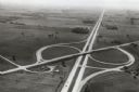
| Description: | Intersection of US Highway 41 and Wisconsin Highway 26 near Oshkosh. |

| Date: | |
|---|---|
| Description: | Rural dirt road in the town of Antigo. Houses are in the distance. |
| Date: | 1922 |
|---|---|
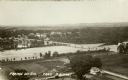
| Description: | Elevated view of bridge over Wisconsin River built in 1921 to take the place of the old wooden bridge when it became condemned. Caption reads: "Prairie Du ... |

| Date: | 10 1905 |
|---|---|
| Description: | Elevated view from Reservoir Bluff to the east of the town. The bluffs of Iowa can be seen in the distance. |
| Date: | 1930 |
|---|---|
| Description: | Elevated view of the north side of town, from high on the bluff. Caption reads: "'Birdseye' No. End Prairie Du Chien, Wis." |

| Date: | 1910 |
|---|---|
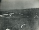
| Description: | Aerial view looking toward Lake Wingra. In the foreground is the Yawkey-Crowley Lumber Yard. The company built it's warehouse at 1542 Monroe Street between... |

| Date: | |
|---|---|
| Description: | Next to a billboard, a road cuts through a field of petroleum derricks. |

| Date: | 1915 |
|---|---|
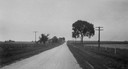
| Description: | Low perspective of a dirt country road curving into the distance. The road is bordered by fields and scattered wooden buildings while a solitary figure ap... |

| Date: | |
|---|---|
| Description: | An oil truck on it way to Salt Creek oil field, at one time responsible for producing approximately one-fifth of all petroleum in the United States. Captio... |
If you didn't find the material you searched for, our Library Reference Staff can help.
Call our reference desk at 608-264-6535 or email us at: