Filter: Categories of Wisconsin Historical Images
Filter: Subject of Fields (Agriculture)
Filter: Subject of roads
Filter: Subject of church buildings
Filter: Categories of Wisconsin Historical Images
Filter: Subject of Fields (Agriculture)
Filter: Subject of roads
Filter: Subject of church buildings

| Date: | 1878 |
|---|---|
| Description: | Bird's-eye map of Kewaskum. Includes a list of hotels, churches, post office, railroad depot, etc. |
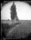
| Date: | |
|---|---|
| Description: | A rural lane lined with Lombardy poplars runs between two fenced fields. Two men are standing in the lane looking towards the camera. A church and many oth... |
| Date: | 1900 |
|---|---|
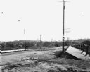
| Description: | View from hill across field towards farmhouses, dwellings and churches along a road. In the foreground are stumps. Caption reads: "Big Falls, Wis." |

| Date: | 10 1928 |
|---|---|
| Description: | Aerial view of Sun Prairie, including the central business district, residences, and the surrounding countryside stretching to the horizon. |
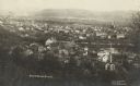
| Date: | 1912 |
|---|---|
| Description: | Elevated view of Wausau from the edge of town looking toward residences and businesses. Hills are in the far background. |
| Date: | |
|---|---|
| Description: | View of Lovers Lane, which a dirt road with a sidewalk and bridge on the right. There are power lines in the foreground, and a town in the background. Ther... |

| Date: | 1925 |
|---|---|
| Description: | View down steep road with guard rail. A car is parked on the side of the road on the right. Over the railing, there is a river and a town with a church bui... |
| Date: | 1921 |
|---|---|
| Description: | View from hill of a church [?], shed, and cemetery in a valley. A dirt road is on the left. |
| Date: | |
|---|---|
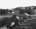
| Description: | Elevated view of a stream with a dam and a bridge. There is a small fenced garden along the water. In the distance is a hillside with houses. |
| Date: | |
|---|---|
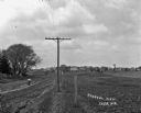
| Description: | View along fence line of a rural area. There is a road on the left and farmland on the right. A person is traveling down the road, visible as a blur. In th... |

| Date: | 1925 |
|---|---|
| Description: | Elevated view of Coon Valley from a hilltop. Trees are on either side of the frame. In the city, there is a cemetery, church, and field of crops. |
| Date: | 07 29 1909 |
|---|---|
| Description: | Aerial view of the downtown area, including a bridge spanning the Trempealeau River. Caption reads: "View of Arcadia, Wisconsin." |

| Date: | 1925 |
|---|---|
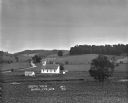
| Description: | View of a church, field, and cemetery from a hilltop. A car drives down the road in the lower-right corner. |

| Date: | |
|---|---|
| Description: | View from hill over church and cemetery towards fields and town in a valley. |
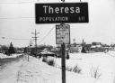
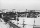
| Date: | 02 01 1978 |
|---|---|
| Description: | "In the early morning hours, a new month dawns on the small village of Theresa. The village is now in the 130th year of its existence." The village marke... |
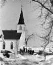
| Date: | 02 16 1978 |
|---|---|
| Description: | "Carrying the casket from Zion, the small country church." |
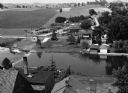
| Date: | 1966 |
|---|---|
| Description: | "This view is from St. Theresa Catholic Church. Looking north toward Zimmel Implement." |

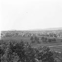
| Date: | 1925 |
|---|---|
| Description: | Elevated view of Mount Vernon from the a grassy hill. |
If you didn't find the material you searched for, our Library Reference Staff can help.
Call our reference desk at 608-264-6535 or email us at: