 Filter: Categories of Wisconsin Historical Images
Filter: Subject of Fields (Agriculture)
Filter: Subject of roads
Filter: Subject of orchards
Filter: Categories of Wisconsin Historical Images
Filter: Subject of Fields (Agriculture)
Filter: Subject of roads
Filter: Subject of orchards
| Date: | |
|---|---|
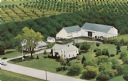
| Description: | Color postcard of an aerial view of Pieper's Fruit Farm. The apple orchards are behind the farmhouse and outbuildings. |

| Date: | 1922 |
|---|---|
| Description: | View from hill of cherry trees in bloom in the Gibraltar Orchard on Sturgeon Bay Road (Highway 42.) |

| Date: | 05 1919 |
|---|---|
| Description: | Elevated view across Sturgeon Bay Road, now Highway 42, toward the Gibraltar Orchard cherry camp. There is a wooden fence in the foreground, and the camp c... |
| Date: | 1958 |
|---|---|
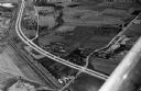
| Description: | Aerial view of Kapec Orchards on Verona Road between McKee and Nesbitt Roads. |
| Date: | 1940 |
|---|---|
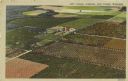
| Description: | Color enhanced aerial postcard view of cherry orchards in Door County. |

| Date: | 03 1777 |
|---|---|
| Description: | Map showing the British and Hessian attack on Fort Washington in November of 1776. The movements and fortifications of the British and Hessian troops appea... |

| Date: | 1948 |
|---|---|
| Description: | Aerial view of a farm in mid-winter. Snow blankets the ground and some of the buildings. An orchard is in the foreground. |

| Date: | 1921 |
|---|---|
| Description: | Text on front reads: "Nightingale Supper Club and Lorraine Supper Club, Sturgeon Bay, Wis." Aerial view of the two businesses on State Highway Business 42,... |
If you didn't find the material you searched for, our Library Reference Staff can help.
Call our reference desk at 608-264-6535 or email us at: