Filter: Categories of Wisconsin Historical Images
Filter: Subject of Fields (Agriculture)
Filter: Subject of water
Filter: Subject of military art and science
Filter: Categories of Wisconsin Historical Images
Filter: Subject of Fields (Agriculture)
Filter: Subject of water
Filter: Subject of military art and science

| Date: | 1950 |
|---|---|
| Description: | Aerial view of the Frank Lloyd-Wright-dsigned Unitarian Church under construction and the Veteran's Administration Hospital, also under construction, to th... |
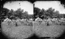
| Date: | 1876 |
|---|---|
| Description: | Quite possibly this is the "View of the Grand Music Band" listed in the "Centennial Views of the City of Madison, July 4th, 1876. Views of Chicago Light Gu... |
| Date: | |
|---|---|
| Description: | Elevated view of helicopters flying over rice fields in Vietnam. |
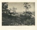
| Date: | 1866 |
|---|---|
| Description: | View of the Chattanooga Valley and a river from Lookout Mountain. Trees are in the foreground, and a city is in the background across the river. Plate 1... |

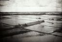
| Date: | 1962 |
|---|---|
| Description: | Three farmers remove large chunks of earth from the side of an irrigation canal in Vietnam to widen it. One man stands with a tool on the bank to dislodge ... |
| Date: | 1962 |
|---|---|
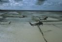
| Description: | Aerial view of four U.S. Marine helicopters banking over an expanse of rice paddies in Vietnam. Fluffy white clouds fill the sky. |

| Date: | 06 1962 |
|---|---|
| Description: | Aerial view of old U.S. Army model H-21 helicopter, assigned to help Vietnamese forces fight the Viet Cong in the mountain region of Vietnam. The patchwork... |

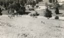
| Date: | 05 1962 |
|---|---|
| Description: | Vietnamese Rangers escort a newly captured prisoner suspected of being Viet Cong down a gravel road in the vicinity of Bac Lien, Vietnam. The prisoner has ... |

| Date: | 1962 |
|---|---|
| Description: | A man caught with Communist propaganda is taken, with his arms bound, to a waiting helicopter. The soldiers who captured him walk behind with weapons raise... |

| Date: | 1862 |
|---|---|
| Description: | This map shows landownership on a military reserve, private claims, buildings (including Fort Howard and U.S. sawmill), swamps, public barns and fields, an... |

| Date: | 03 1777 |
|---|---|
| Description: | Map showing the British and Hessian attack on Fort Washington in November of 1776. The movements and fortifications of the British and Hessian troops appea... |

| Date: | 1776 |
|---|---|
| Description: | Fairly detailed map of New York City and parts of Long Island. It shows streets, roads, wharves, ferries, ship yards, Fort George and the battery, public b... |
If you didn't find the material you searched for, our Library Reference Staff can help.
Call our reference desk at 608-264-6535 or email us at: