 Filter: Categories of Wisconsin Historical Images
Filter: Subject of Fortification
Filter: Creator Name of Unknown
Filter: Subject of hills
Filter: Categories of Wisconsin Historical Images
Filter: Subject of Fortification
Filter: Creator Name of Unknown
Filter: Subject of hills

| Date: | 1830 |
|---|---|
| Description: | Illustration of Fort Crawford. Caption reads: "Fort Crawford in 1830, Prairie Du Chien, Wis." |

| Date: | 1840 |
|---|---|
| Description: | Fort Crawford (the second site, with buildings of 1829-?), on the east bank of the Mississippi River, about 2 miles above the mouth of the Wisconsin River. |

| Date: | 1875 |
|---|---|
| Description: | Fort Crawford ruins. This image may be even earlier than 1875; by the 1880's almost nothing was left of the actual fort compound buildings. Men are sitting... |

| Date: | 1840 |
|---|---|
| Description: | A view of Fort Crawford (the second site and buildings of 1829-?). |
| Date: | 1898 |
|---|---|
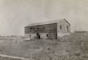
| Description: | Ruins of the commissary warehouse at Fort Winnebago, about 1898. Fort Winnebago was closed in 1845 and the land and buildings sold. Today, only the Surgeon... |
| Date: | |
|---|---|
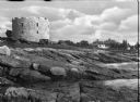
| Description: | View from rocky shore toward the stone tower at Fort William Henry. Four automobiles are parked in front of the tower, with houses and other buildings in t... |
| Date: | |
|---|---|
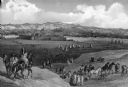
| Description: | An illustrated view of Fort Union (on the North Dakota-Montana boundary), with an Indian encampment. |
| Date: | |
|---|---|
| Description: | A view of West Point from Garrison, New York, across the river. The military academy was designed in l778, and was built on the bank of the Hudson River. C... |
| Date: | |
|---|---|
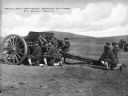
| Description: | A view of soldiers in an open field during artillery practice at The School of Fire, founded in 1911 at Fort Sill. Caption reads: "Artillery Practice, Scho... |
| Date: | |
|---|---|
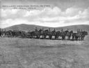
| Description: | A view of horse-drawn artillery at the School of Fire, established in 1911 at Fort Sill. Caption reads: "Artillery Practice, School of Fire, Ft. Sill, OKLA... |

| Date: | |
|---|---|
| Description: | A hand-drawn map including the location of Daniel Boone's home and two forts, northeast of Lexington, Kentucky. |

| Date: | 1918 |
|---|---|
| Description: | View looking up hill towards Blockhouse No. 1 that is constructed from timbers and earth. The fortification appears to be partially constructed into the to... |
| Date: | |
|---|---|
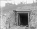
| Description: | The entrance of an underground bunker built into the side of a hill. The entrance is supported with timber and wooden planks and has wooden flooring. Above... |

| Date: | 05 08 1927 |
|---|---|
| Description: | Two men are standing by a sign, near a fence, marking the former location of Fort Antoine. |
If you didn't find the material you searched for, our Library Reference Staff can help.
Call our reference desk at 608-264-6535 or email us at: