Filter: Categories of Wisconsin Historical Images
Filter: Subject of Fortification
Filter: Subject of land
Filter: Categories of Wisconsin Historical Images
Filter: Subject of Fortification
Filter: Subject of land

| Date: | 1830 |
|---|---|
| Description: | Fort Winnebago from an original drawing by Jefferson Davis. |

| Date: | 1840 |
|---|---|
| Description: | This map, one of a series made by Thomas Jefferson Cram of the U.S. Topographical Engineers from personal surveys, shows the portage connecting the Wiskons... |

| Date: | 1840 |
|---|---|
| Description: | Fort Crawford (the second site, with buildings of 1829-?), on the east bank of the Mississippi River, about 2 miles above the mouth of the Wisconsin River. |

| Date: | 1875 |
|---|---|
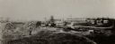
| Description: | Fort Crawford ruins. This image may be even earlier than 1875; by the 1880's almost nothing was left of the actual fort compound buildings. Men are sitting... |

| Date: | 1840 |
|---|---|
| Description: | A view of Fort Crawford (the second site and buildings of 1829-?). |

| Date: | 1829 |
|---|---|
| Description: | Fort Crawford, from a sketchbook attributed to Seth Eastman, 1808-1875. A graduate of West Point, Eastman briefly served at Fort Crawford, 1829-1839. |

| Date: | 1831 |
|---|---|
| Description: | Fort Winnebago, a print published in Mrs. John H. Kinzie's Wau-bun (1856). |
| Date: | 1898 |
|---|---|
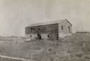
| Description: | Ruins of the commissary warehouse at Fort Winnebago, about 1898. Fort Winnebago was closed in 1845 and the land and buildings sold. Today, only the Surgeon... |

| Date: | 1829 |
|---|---|
| Description: | Hand-colored lithograph of Fort Armstrong on Rock Island, based on a drawing by Henry Lewis. Foreground shows a tree floating in the water. |

| Date: | 1829 |
|---|---|
| Description: | Hand-colored lithograph of Fort Armstrong, based on a drawing by Henry Lewis. Includes boats on the Mississippi River. |
| Date: | |
|---|---|
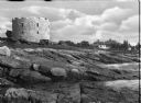
| Description: | View from rocky shore toward the stone tower at Fort William Henry. Four automobiles are parked in front of the tower, with houses and other buildings in t... |
| Date: | |
|---|---|
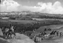
| Description: | An illustrated view of Fort Union (on the North Dakota-Montana boundary), with an Indian encampment. |

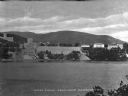
| Date: | |
|---|---|
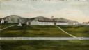
| Description: | Elevated view of Fort Seward from Mount Rippinsky, showing Pyramid Harbor and Davidson Glacier in distance. Caption reads: "Haines and Fort Wm. H. Seward f... |

| Date: | 1864 |
|---|---|
| Description: | View across the Tennessee River toward the city and Cameron Hill, showing the military bridge and some Union Army installations put up following the occupa... |
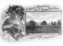
| Date: | |
|---|---|
| Description: | A Christmas Card with two views. The on on the left is featuring an image of a girl sledding while wearing winter gear, and on the right is a photograph of... |
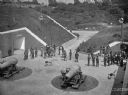
| Date: | |
|---|---|
| Description: | Elevated view of a group of men standing by large guns. |
| Date: | |
|---|---|
| Description: | A view of West Point from Garrison, New York, across the river. The military academy was designed in l778, and was built on the bank of the Hudson River. C... |
If you didn't find the material you searched for, our Library Reference Staff can help.
Call our reference desk at 608-264-6535 or email us at: