 Filter: Categories of Wisconsin Historical Images
Filter: Subject of Fortification
Filter: Subject of land
Filter: Categories of Wisconsin Historical Images
Filter: Subject of Fortification
Filter: Subject of land
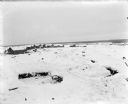
| Date: | 1918 |
|---|---|
| Description: | Trenches constructed for American forces to defend against the Bolshevik "Red" forces. In the background are possibly barracks and other buildings for the ... |
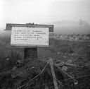
| Date: | 10 29 1944 |
|---|---|
| Description: | A German warning sign nailed to a tree trunk. Just beyond the sign are dragon's teeth, concrete pyramids put in to stop tanks, on the Siegfried Line, a lin... |

| Date: | 1918 |
|---|---|
| Description: | Looking up at Blockhouse No. 4 while under construction. Trees around the constructions site are being used to provide camouflage. |

| Date: | 1918 |
|---|---|
| Description: | View looking up hill towards Blockhouse No. 1 that is constructed from timbers and earth. The fortification appears to be partially constructed into the to... |
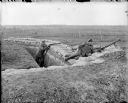
| Date: | 1918 |
|---|---|
| Description: | Two British soldiers posing in a trench. The soldier on the right is manning an air-cooled Vickers light machine gun, and the soldier on the left is holdin... |
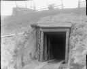
| Date: | |
|---|---|
| Description: | The entrance of an underground bunker built into the side of a hill. The entrance is supported with timber and wooden planks and has wooden flooring. Above... |

| Date: | 1887 |
|---|---|
| Description: | This etching by Amidon G. Miller covers portions of the towns of Nelson and Stockholm in Pepin County, Wisconsin, as well as a portion of the Town of Maide... |

| Date: | 1836 |
|---|---|
| Description: | This map of Navarino shows a development plat of the village situated opposite Fort Howard at mouth of the Fox River. The names of proprietors are listed a... |

| Date: | 1900 |
|---|---|
| Description: | This map of Green Bay shows plat of the town, lots by number, local streets, the military Fort Howard, part of Fox River and part of Navarino. The map feat... |

| Date: | 1930 |
|---|---|
| Description: | This map shows a plat of the town, local streets, railroads, creeks, part of Fox River, and part of the bay of Green Bay. The location of the original fort... |

| Date: | 1882 |
|---|---|
| Description: | This map is ink on cardboard and shows the location of military forts over the course of years. Also shown are points of interest, streets, the Mississippi... |

| Date: | 1950 |
|---|---|
| Description: | Intended for tourists, this brochure features two maps with tourists sites along the Mississippi River. One map shows roads and populated places along the ... |

| Date: | 1800 |
|---|---|
| Description: | This map shows the land claim owned by the Portage Canal Company and includes an index of landownership and landmarks. The Wisconsin and Portage River, the... |

| Date: | 1800 |
|---|---|
| Description: | This map is pencil on tracing paper and shows marshes, the Wisconsin River, Indian trails, and Indian boundary line. The upper left corner reads: "Let sect... |

| Date: | 1856 |
|---|---|
| Description: | This map shows lot and block numbers, streets, the Mississippi River, Fort Crawford, depot ground, and a graveyard. An old fort location is outlined in red... |

| Date: | 12 05 1854 |
|---|---|
| Description: | This plat map shows landowners, the Mississippi River, the Marais de St. Friole, and an old fort. The left margin reads: "Part of the Main Village of Prair... |

| Date: | 1828 |
|---|---|
| Description: | This plat map is pen-and-ink and shows landowners, the Mississippi River, the Marais de St. Friole, Fort Crawford, the town commons, and the Village of St.... |

| Date: | 07 28 1934 |
|---|---|
| Description: | This map shows buildings and dimensions of Fort Crawford and hospital overlaid on a plat of existing lots, streets, and closed streets. |

| Date: | 1855 |
|---|---|
| Description: | This map shows landownership, lot and block numbers, streets, a canal, bridges, Fort Winnebago, the Wisconsin River, and the Fox River. Relief is shown by ... |

| Date: | 1840 |
|---|---|
| Description: | This map shows a line of proposed construction for defending the north side of the canal against inundation from the Wisconsin River and location of Fort W... |
If you didn't find the material you searched for, our Library Reference Staff can help.
Call our reference desk at 608-264-6535 or email us at: