 Filter: Categories of Wisconsin Historical Images
Filter: Subject of Fortification
Filter: Year of 1800-1899
Filter: Subject of land
Filter: Year of 1850-1859
Filter: Categories of Wisconsin Historical Images
Filter: Subject of Fortification
Filter: Year of 1800-1899
Filter: Subject of land
Filter: Year of 1850-1859
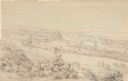
| Date: | 1852 |
|---|---|
| Description: | Landscape view of Fort Snelling, Minnesota Territory from a nearby hill showing the Fort, the Mississippi river, the countryside, farm buildings and tipis.... |

| Date: | 1850 |
|---|---|
| Description: | A hand-colored map showing portions of present-day Iron and Vilas counties north of the Manitowish River as part of the Upper Peninsula of Michigan. The Wi... |

| Date: | 1852 |
|---|---|
| Description: | A hand-colored map showing portions of present-day Iron and Vilas counties north of the Manitowish River as part of the Upper Peninsula of Michigan. The Wi... |

| Date: | 1856 |
|---|---|
| Description: | This map shows lot and block numbers, streets, the Mississippi River, Fort Crawford, depot ground, and a graveyard. An old fort location is outlined in red... |

| Date: | 12 05 1854 |
|---|---|
| Description: | This plat map shows landowners, the Mississippi River, the Marais de St. Friole, and an old fort. The left margin reads: "Part of the Main Village of Prair... |

| Date: | 1855 |
|---|---|
| Description: | This map shows landownership, lot and block numbers, streets, a canal, bridges, Fort Winnebago, the Wisconsin River, and the Fox River. Relief is shown by ... |
If you didn't find the material you searched for, our Library Reference Staff can help.
Call our reference desk at 608-264-6535 or email us at: