 Filter: Categories of Wisconsin Historical Images
Filter: Subject of Fortification
Filter: Year of 1800-1899
Filter: Year of 1830-1839
Filter: Year of 1835
Filter: Categories of Wisconsin Historical Images
Filter: Subject of Fortification
Filter: Year of 1800-1899
Filter: Year of 1830-1839
Filter: Year of 1835

| Date: | 1835 |
|---|---|
| Description: | Little Lake Butte Des Morts just north of Lake Winnebago where Governor Lewis Cass of Michigan, and Thomas McKenney, head of the Bureau of Indian Affairs (... |
| Date: | 1835 |
|---|---|
| Description: | This map covers the Western Territory of the United States from the Rocky Mountains in Colorado south to Fort Smith, Arkansas, and from the Pacific Ocean e... |

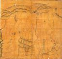
| Date: | 1835 |
|---|---|
| Description: | Map shows the Fox River, lot and block numbers, private claims, streets, a public squares, a manual labour school, and Fort Howard. An inset map shows a pl... |
If you didn't find the material you searched for, our Library Reference Staff can help.
Call our reference desk at 608-264-6535 or email us at: