 Filter: Categories of Wisconsin Historical Images
Filter: Subject of Fortification
Filter: Year of 1800-1899
Filter: Year of 1860-1869
Filter: Type of Map or Atlas
Filter: Categories of Wisconsin Historical Images
Filter: Subject of Fortification
Filter: Year of 1800-1899
Filter: Year of 1860-1869
Filter: Type of Map or Atlas

| Date: | 1862 |
|---|---|
| Description: | This map lists and depicts the positions of "the batteries on Kentucky shore" and the "batteries on Island No. 10." The 8th Wisconsin Infantry and 15th Wis... |
| Date: | 1862 |
|---|---|
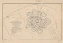
| Description: | This detailed plan of Fort Jackson, in Plaquemines Parish, Louisiana, indicates the damage inflicted by the April, 1862, bombardment of the fort by Union f... |

| Date: | 1863 |
|---|---|
| Description: | This map illustrates the position of Fort Hindman at Arkansas Post on the Arkansas River. Depicted are the positions of Confederate defenses as well ships ... |

| Date: | 1864 |
|---|---|
| Description: | This map created during the Civil War indicates Confederate fortifications, houses, names of residents, towns, roads, railroads, relief by hachures, draina... |

| Date: | 1864 |
|---|---|
| Description: | Map of eastern Virginia and part of Maryland, showing engagements by crossed swords, fortifications surrounding Richmond, routes of the opposing armies fro... |

| Date: | 1865 |
|---|---|
| Description: | Detailed map of the southeastern United States showing fortifications, "movements of Genl. J.H. Wilson's Cavalry Corps," "pursuit of Hood" and the lines of... |

| Date: | 1862 |
|---|---|
| Description: | Map of southeastern Virginia indicating fortifications, towns, roads, railroads, drainage, and some vegetation. 2 sheets, each mounted on 1 sheet. |

| Date: | 1860 |
|---|---|
| Description: | A survey map of Wisconsin, southeastern Minnesota, and northern Iowa, showing the status of surveys, rivers, and lakes. The map also shows the locations of... |

| Date: | 1867 |
|---|---|
| Description: | This 1867 manuscript map by Increase Lapham shows the topography and geology of the Blue Mounds region in the Town of Brigham in Iowa County and the towns ... |

| Date: | 1865 |
|---|---|
| Description: | This map shows fortifications, headquarters, and location and dates of battles. Relief is shown by hachures. A list of authorities is included. Blue lines ... |

| Date: | 1862 |
|---|---|
| Description: | This map shows landownership on a military reserve, private claims, buildings (including Fort Howard and U.S. sawmill), swamps, public barns and fields, an... |
If you didn't find the material you searched for, our Library Reference Staff can help.
Call our reference desk at 608-264-6535 or email us at: