Filter: Categories of Wisconsin Historical Images
Filter: Subject of Fortification
Filter: Year of 1800-1899
Filter: Categories of Wisconsin Historical Images
Filter: Subject of Fortification
Filter: Year of 1800-1899

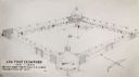
| Date: | 1830 |
|---|---|
| Description: | Fort Winnebago from an original drawing by Jefferson Davis. |

| Date: | 1840 |
|---|---|
| Description: | This map, one of a series made by Thomas Jefferson Cram of the U.S. Topographical Engineers from personal surveys, shows the portage connecting the Wiskons... |
| Date: | 1814 |
|---|---|
| Description: | Fort Shelby built in 1814 and named for the Governor of Kentucky, was surrendered to British forces later in 1814 and renamed Fort McKay. Pictured here is ... |

| Date: | 1814 |
|---|---|
| Description: | Fort Shelby, built by the Americans during the War of 1812. In 1814 the fort surrendered to British forces led by Captain Andrew W. Bulger who renamed it F... |

| Date: | 1840 |
|---|---|
| Description: | Fort Crawford (the second site, with buildings of 1829-?), on the east bank of the Mississippi River, about 2 miles above the mouth of the Wisconsin River. |
| Date: | 1817 |
|---|---|
| Description: | Sketch of an elevated view of Fort Crawford (1816-1829). |

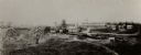
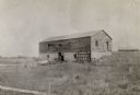
| Date: | 1875 |
|---|---|
| Description: | Fort Crawford ruins. This image may be even earlier than 1875; by the 1880's almost nothing was left of the actual fort compound buildings. Men are sitting... |

| Date: | 1840 |
|---|---|
| Description: | A view of Fort Crawford (the second site and buildings of 1829-?). |
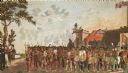
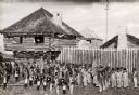
| Date: | 1823 |
|---|---|
| Description: | British evacuation of their fort at Prairie du Chien after the end of the War of 1812. Fort Shelby, the first fort at Prairie du Chien, was built in 1814 b... |

| Date: | 1829 |
|---|---|
| Description: | Fort Crawford, from a sketchbook attributed to Seth Eastman, 1808-1875. A graduate of West Point, Eastman briefly served at Fort Crawford, 1829-1839. |

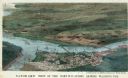
| Date: | 1855 |
|---|---|
| Description: | Fox-Wisconsin portage and canal map, when the canal was not yet built. From a map in the office of the city clerk at Portage. "The old trail, the location ... |

| Date: | 1831 |
|---|---|
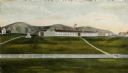
| Description: | Fort Winnebago, a print published in Mrs. John H. Kinzie's Wau-bun (1856). |
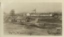
| Date: | 1898 |
|---|---|
| Description: | Ruins of the commissary warehouse at Fort Winnebago, about 1898. Fort Winnebago was closed in 1845 and the land and buildings sold. Today, only the Surgeon... |

| Date: | 1829 |
|---|---|
| Description: | Hand-colored lithograph of Fort Armstrong on Rock Island, based on a drawing by Henry Lewis. Foreground shows a tree floating in the water. |

| Date: | 1829 |
|---|---|
| Description: | Hand-colored lithograph of Fort Armstrong, based on a drawing by Henry Lewis. Includes boats on the Mississippi River. |
| Date: | 04 1862 |
|---|---|
| Description: | Stationery depicting the fortifications around Washington, D.C., during the second year of the Civil War: Arlington Heights, directly across the Potomac Ri... |
If you didn't find the material you searched for, our Library Reference Staff can help.
Call our reference desk at 608-264-6535 or email us at: