 Filter: Categories of Wisconsin Historical Images
Filter: Subject of Geology
Filter: Subject of human settlements
Filter: Year of 1800-1899
Filter: Categories of Wisconsin Historical Images
Filter: Subject of Geology
Filter: Subject of human settlements
Filter: Year of 1800-1899

| Date: | 1865 |
|---|---|
| Description: | Map showing the location of meteorological stations and effects that Lake Michigan has had on Wisconsin temperatures in January and July. The map shows cou... |

| Date: | 1873 |
|---|---|
| Description: | A hand-colored, geological map of the Fox and Wisconsin rivers’ water path from the Mississippi River to the Great Lakes. The map also shows those railroad... |
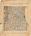
| Date: | 1876 |
|---|---|
| Description: | This color-coded map of the geology of southeastern Wisconsin shows the township grid, counties, towns, cities and villages, rivers, lakes, and railroads. ... |

| Date: | 1836 |
|---|---|
| Description: | A detailed map of the mouth of the Kewaunee River, showing the geological composition of the Lake Michigan shoreline and the various water depths in the ar... |

| Date: | 1883 |
|---|---|
| Description: | This map shows the geology of areas in Montana, the Dakotas, Nebraska, Wyoming, Idaho, Colorado, Kansas, Arizona, New Mexico, and Utah. Map also shows lake... |

| Date: | 1892 |
|---|---|
| Description: | This map shows rivers, lakes, railroad lines, roads, and communities in addition to geological data. The map includes cross-sections in the bottom margin a... |

| Date: | 1878 |
|---|---|
| Description: | This map shows geographic regions of the entire state. The bottom left corner includes an "Explanation of Color": Laurentien Granite (pink), Huronian Iron-... |

| Date: | 1839 |
|---|---|
| Description: | This map shows the geological makeup of the valley in red, yellow, and green, the Mississippi River, and the location of Fort Crawford. The geology on the ... |
If you didn't find the material you searched for, our Library Reference Staff can help.
Call our reference desk at 608-264-6535 or email us at: