 Filter: Categories of Wisconsin Historical Images
Filter: Subject of Great Lakes
Filter: Subject of landforms
Filter: Categories of Wisconsin Historical Images
Filter: Subject of Great Lakes
Filter: Subject of landforms

| Date: | 1898 |
|---|---|
| Description: | Bird's-eye map, looking west from shoreline on Lake Michigan of Milwaukee to Golden Lake in Waukesha County, with Kenosha and Fox Point at bottom corners, ... |

| Date: | 1910 |
|---|---|
| Description: | Bird's-eye view looking east, with Washburn Harbor at center and Chequamegon Bay in Lake Superior covering most of the upper image. Streets with buildings... |

| Date: | 1632 |
|---|---|
| Description: | The Wisconsin portion of Champlain's 1632 map, augmented since the previous one, for navigation according to the true Meridien, by Sieur de Champlain. The ... |

| Date: | 1769 |
|---|---|
| Description: | Manuscript map. Scale: about 80 British statue miles to 1 inch. |

| Date: | 1670 |
|---|---|
| Description: | This map is in French and shows Lac Tracy ov Superieur (Lake Superior), Baye des Puans (Green Bay), and portions of Lac des Ilinois (Lake Michigan) and Lac... |

| Date: | 1776 |
|---|---|
| Description: | In French: "Partie Occidentale du Canada et septentrionale de la Louisiane avec une partie de la Pensilvanie." A map showing graticule and six European sca... |

| Date: | 1830 |
|---|---|
| Description: | A color map of the Michigan and Wisconsin territories with an inset showing the Ste. Marie River. |

| Date: | 1910 |
|---|---|
| Description: | Wisconsin Geological and Natural History Survey, by Lawrence Martin reproduced from a model of the state prepared by W.O. Hotchkiss and F.T. Thwaites and m... |

| Date: | 1862 |
|---|---|
| Description: | Lithography of C. Van Benthuysen. |

| Date: | 1839 |
|---|---|
| Description: | Shows locations of cities, towns, villages, post hamlets, canals, rail and stage roads. Includes table of steamboat routes and distances; vignette of "Maid... |

| Date: | 1755 |
|---|---|
| Description: | Hand-colored. Paris: 1755. Scale [ca. 1:3,000,000]. |

| Date: | 1852 |
|---|---|
| Description: | Map shows Wisconsin counties by color and includes rivers, lakes and some cities. This information is also given for eastern Minnesota and northern Illinoi... |

| Date: | 1785 |
|---|---|
| Description: | Map of part of North America engraved and hand-colored (the light brown design is a superposition of the map and cartouche derived from the oxidation of th... |

| Date: | |
|---|---|
| Description: | Aerial view of harbor, with shipyards in the foreground and Superior in the background. Caption reads: "Aerial View of Harbor, Superior, Wisconsin." |
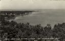
| Date: | |
|---|---|
| Description: | Elevated view of Green Bay from the Alpine Tower at Egg Harbor. A few dwellings are along the shoreline on the left. Caption reads: "View from the Alpine T... |

| Date: | |
|---|---|
| Description: | Aerial view of Ephraim and Eagle Bay. A two-lane highway runs along the coastline. Caption reads: "Ephraim, Wisconsin." |
If you didn't find the material you searched for, our Library Reference Staff can help.
Call our reference desk at 608-264-6535 or email us at:
