Filter: Categories of Wisconsin Historical Images
Filter: Subject of Guard fences
Filter: Subject of roads
Filter: Subject of guard fences
Filter: Categories of Wisconsin Historical Images
Filter: Subject of Guard fences
Filter: Subject of roads
Filter: Subject of guard fences
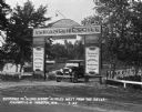
| Date: | 07 1927 |
|---|---|
| Description: | Car parked underneath the entrance gate to the Island Resort at the Wisconsin Dells, 25 miles from the Dells on Highway 12-16 near Mauston. Entrance gate a... |
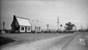
| Date: | 10 23 1934 |
|---|---|
| Description: | Cities Service Gas Station featuring Kool Motor gasoline. Looking east from the corner of Femrite Road and Buckeye Road (Highway AB). |
| Date: | 11 18 1930 |
|---|---|
| Description: | Trees cut down along US Hwy 12, South Beltline Highway, between John Nolen Drive & South Towne Drive. "Between the overhead grade crossing viaduct and the ... |
| Date: | 11 18 1930 |
|---|---|
| Description: | Trees cut down along US Hwy 12, South Beltline Highway, between John Nolen Drive & South Towne Drive. "Between the overhead grade crossing viaduct and the ... |
| Date: | 01 09 1928 |
|---|---|
| Description: | Difference in paint on fences on a state highway. |
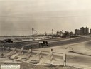
| Date: | 1933 |
|---|---|
| Description: | View from Outer Lake Shore Drive looking south from Foster Avenue. Lake Michigan and the Chicago skyline are in the background. |
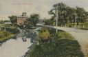
| Date: | 1910 |
|---|---|
| Description: | Distant view of the mill, with a stream leading to it, and a road paralleling the stream on the right. Caption reads: "The Old Mill, Delavan, Wis." |
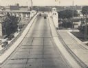
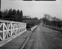
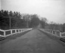
| Date: | 1935 |
|---|---|
| Description: | Elevated view of the bridge, with several cars driving on it. On the left and right are streets below the bridge. In the distance are smokestacks and water... |
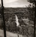
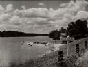
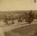
| Date: | 1950 |
|---|---|
| Description: | View from hill through two trees over a road with a guard fence, overlooking the town laid out along a main thoroughfare. The area is heavily forested, and... |
| Date: | 1935 |
|---|---|
| Description: | View of Kohler Ravine Park. In the right foreground is a small bridge, and on the right is a set of wide, concrete steps leading from the road down the hil... |
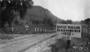
| Date: | 1927 |
|---|---|
| Description: | View of the Battle Hollow sign along an unpaved road. In the distance on the left is a rock formation covered with trees. Sign reads: "Battle Hollow Clack ... |
| Date: | 1880 |
|---|---|
| Description: | The view of Red Cedar River from Meadow Hill. |
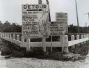
| Date: | 1920 |
|---|---|
| Description: | Detour sign posted by the Wisconsin Highway Commission, the predecessor of the Department of Transportation, in Manitowoc showing a confusing detour route ... |
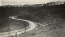
| Date: | 1920 |
|---|---|
| Description: | Loganville Road in Sauk County taken by the Wisconsin Good Roads Association. The photograph was meant to create a contrast between the new improved road ... |
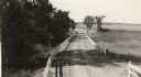
| Date: | 1918 |
|---|---|
| Description: | Amery Road near New Richmond. The photograph was taken by the Wisconsin Good Roads Association probably as an illustration of the kind of improved roads t... |
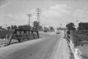
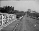
| Date: | 08 07 1945 |
|---|---|
| Description: | State Highway 113 bridge over the Yahara River in Westport. The photograph is taken from the south end of the bridge showing the highway going straight ahe... |
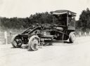
| Date: | 07 20 1929 |
|---|---|
| Description: | Emil Anderson operates a road grader marked "Russell Motor Patrol No.3" on Highway 12. |
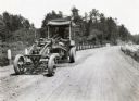
| Date: | 07 20 1927 |
|---|---|
| Description: | Emil Anderson operating a road grader marked "Russell Motor Patrol No.3" on Highway 12. |
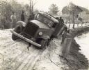
| Date: | 12 08 1936 |
|---|---|
| Description: | Men gather around an International D-40 truck stuck in soft sand on a road along a shoreline. |
If you didn't find the material you searched for, our Library Reference Staff can help.
Call our reference desk at 608-264-6535 or email us at: