 Filter: Categories of Wisconsin Historical Images
Filter: Subject of Iroquois Indians
Filter: Subject of arts
Filter: Categories of Wisconsin Historical Images
Filter: Subject of Iroquois Indians
Filter: Subject of arts
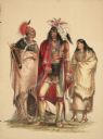
| Date: | 1844 |
|---|---|
| Description: | Portrait of North American Indians (Plate 1). "The group in Plate No. 1 is composed of three Portraits from my collection, representing three different t... |

| Date: | 1777 |
|---|---|
| Description: | This detailed map of the American colonies shows cities, villages, roads, mountains, lakes, rivers, swamps, counties, state boundaries, and Native American... |

| Date: | 02 04 1783 |
|---|---|
| Description: | One of the first and few maps to attempt to map the new boundaries of the United States and British territories during the preliminary treaty at the end of... |
If you didn't find the material you searched for, our Library Reference Staff can help.
Call our reference desk at 608-264-6535 or email us at: