 Filter: Categories of Wisconsin Historical Images
Filter: Subject of Islands
Filter: Creator Name of Unknown
Filter: Categories of Wisconsin Historical Images
Filter: Subject of Islands
Filter: Creator Name of Unknown

| Date: | 1940 |
|---|---|
| Description: | This map of La Crosse shows different types of land zoning: residence, multiple dwelling, local business, commercial, light industrial, heavy industrial, w... |

| Date: | 1800 |
|---|---|
| Description: | This map of the Little Kaukalin Region is ink on paper and shows Little Kaukalin Rapids, Black Bird Island, buildings, trails, meadows and woods, and a sug... |
| Date: | 1912 |
|---|---|
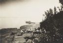
| Description: | Picnic party on the rocks along the shore, among the Apostle Islands in Lake Superior. |
| Date: | 08 09 1890 |
|---|---|
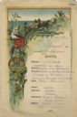
| Description: | One-page menu from the R.M.S.S. Magdalena of the Royal Mail Steam Packet Company, with a parrot and a cockatiel perched on a branch above the compan... |

| Date: | 1836 |
|---|---|
| Description: | This is a cadastral map and shows proposed lot and block numbers for a paper city on the banks of the Rock River. Also shown are two public squares and som... |

| Date: | 07 2001 |
|---|---|
| Description: | David Obey poses with Park Ranger Geoffrey Smith on the left and Martin Hanson on the right. They are standing on the beach with water and land in the back... |

| Date: | |
|---|---|
| Description: | Letterhead of Johnson & Melaas, merchant tailors and cloth dealers, "Buyers of wool and Wisconsin leaf tobacco," with an engraving of a waterfront view of ... |

| Date: | 1910 |
|---|---|
| Description: | Doctor Thorne was one of the members of Carrie's travel party. He is pictured here, in front of Victoria Falls on Livingstone Island. |

| Date: | 1910 |
|---|---|
| Description: | Photographic postcard of elevated view of the Wilcox Stone Mill, and part of Broadway showing the rear view of B.F. Smith's store below the hand-drawn arro... |
| Date: | 1910 |
|---|---|
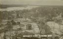
| Description: | Elevated view of the town with snow on the ground. Houses are near an intersection in the foreground, and homes and commercial buildings are along the shor... |

| Date: | 1910 |
|---|---|
| Description: | Photographic postcard view of "Helen's Isle" in a lake. |

| Date: | 04 15 1915 |
|---|---|
| Description: | A sketch of Little Lake Butte des Morts and the surrounding area, including Neenah and Menasha. |

| Date: | 1900 |
|---|---|
| Description: | This blue line print map shows land use, cables, U.S.L.S.S. walk and clearing, and front and rear range lights on the Porte des Morts Passage. Tree types a... |

| Date: | |
|---|---|
| Description: | View across water towards Governor's Island and its exposed cliff at the shoreline with trees and plants growing on top. Governor’s Island, formerly part o... |

| Date: | 01 07 1894 |
|---|---|
| Description: | Winter view of early buildings on Rocky Roost, which was west of Governor's Island. There is snow on the roofs, on the rocks and on the shore of Lake Mendo... |

| Date: | 1910 |
|---|---|
| Description: | This map shows shoreline lot numbers and acreages, the Wisconsin River, and the Michigan and Wisconsin state line. Manuscript annotations relating to topon... |

| Date: | |
|---|---|
| Description: | View from shoreline of a lake. Trees and plants are in the foreground, and across the water may be islands as well as the far shoreline, which are tree-cov... |

| Date: | |
|---|---|
| Description: | View from shoreline over a marshy area towards a lake at Northern Lakes Park. There is a tree-covered shoreline in the far background. There may be an isl... |

| Date: | 1857 |
|---|---|
| Description: | This map shows lot and block numbers, streets, railroad depots, locks, bridges, dams, canals, U.S. light house, college grounds, a steam boat landing, and ... |

| Date: | 1936 |
|---|---|
| Description: | This map shows campsites, trails, auto roads, surrounding townships, and points of interest, by including pictorial illustrations. Includes an inserted map... |
If you didn't find the material you searched for, our Library Reference Staff can help.
Call our reference desk at 608-264-6535 or email us at: