 Filter: Categories of Wisconsin Historical Images
Filter: Subject of Lakes
Filter: Subject of water
Filter: Subject of roads
Filter: Categories of Wisconsin Historical Images
Filter: Subject of Lakes
Filter: Subject of water
Filter: Subject of roads

| Date: | 1936 |
|---|---|
| Description: | This map is red and black ink on tracing cloth and is oriented with north to the upper left. This hand-drawn map shows a central portion of the military ro... |

| Date: | 1908 |
|---|---|
| Description: | A panoramic aerial view of the Isthmus taken from a kite. Lake Mendota is to the right in the background with Picnic Point jutting into the lake. The photo... |

| Date: | 1873 |
|---|---|
| Description: | Map of the township of Windsor, from the "Atlas of Dane County." |

| Date: | 1856 |
|---|---|
| Description: | View looking west from Lake Michigan with several steam ships and sailing vessels in harbor. There is a lighthouse to left of center, along shoreline. |
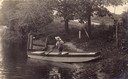
| Date: | |
|---|---|
| Description: | Laurie Peterson, son of the photographer, plays in boat. The photograph was originally titled "The Lone Boatsman". |

| Date: | 1876 |
|---|---|
| Description: | Bird's-eye view of Black Earth. |

| Date: | 05 09 1908 |
|---|---|
| Description: | Kite aerial panoramic photograph of the central business district. In the distance is Lake Mendota. The fire damaged Wisconsin State Capitol is in the cent... |

| Date: | 1861 |
|---|---|
| Description: | View of Madison from Main Hall, now Bascom Hall, on the University of Wisconsin-Madison campus looking up State Street toward the second Wisconsin State Ca... |

| Date: | 1832 |
|---|---|
| Description: | Hand-drawn map in two parts of the route of Governor J.D. Doty. Probably made by Doty in 1832 as a result of his travels with Alexander J. Center. |

| Date: | 1879 |
|---|---|
| Description: | Bird's-eye view of Wisconsin State University, now the University of Wisconsin-Madison. Vignettes include Ladies Hall, South Dormitory, University Hall, As... |

| Date: | 1867 |
|---|---|
| Description: | Birds-eye drawing of Beaver Dam, Dodge Co., depicting street names and street layout, houses, rivers, lakes, and trees. A reference key at the bottom of th... |

| Date: | 1885 |
|---|---|
| Description: | Bird's-eye map of Madison, State Capital of Wisconsin, County Seat of Dane County, with inset of the Wisconsin State Capitol. |

| Date: | 1852 |
|---|---|
| Description: | Pencil drawing of Madison landscape as seen from University Hill. The main street in the center is State Street, and the building with Greek columns in the... |

| Date: | 1885 |
|---|---|
| Description: | Bird's-eye map of Oconomowoc. |

| Date: | 1885 |
|---|---|
| Description: | Bird's-eye view of Sheboygan, with inset of J.J. Volrath Manufacturing Company. |

| Date: | 1882 |
|---|---|
| Description: | Bird's-eye map of Lake Geneva, looking southwest, with insets of points of interest. |

| Date: | 1867 |
|---|---|
| Description: | Bird's-eye map of Ripon, with insets of points of interest. |

| Date: | 1913 |
|---|---|
| Description: | Bird's-eye map of Superior. "The New Steel Center." |

| Date: | 01 02 1940 |
|---|---|
| Description: | Exterior view of University of Wisconsin Memorial Union Theater wing, taken from Park and Langdon Streets. |
If you didn't find the material you searched for, our Library Reference Staff can help.
Call our reference desk at 608-264-6535 or email us at:
