Filter: Categories of Wisconsin Historical Images
Filter: Subject of Lakes
Filter: Categories of Wisconsin Historical Images
Filter: Subject of Lakes

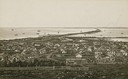
| Date: | 1870 |
|---|---|
| Description: | Bird's-eye view of Whitewater, with insets. |

| Date: | 1890 |
|---|---|
| Description: | Colored bird's-eye map of Oconomowoc and the Lake Region, Waukesha County. Looking North from Government Hill. Location key below image identifies 24 Hotel... |

| Date: | 1949 |
|---|---|
| Description: | Color bird's-eye map of the University of Wisconsin-Madison as it was midcentury, with two co-eds, several photographs of campus landmarks around edges, an... |
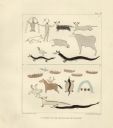
| Date: | 1851 |
|---|---|
| Description: | Pictographs on Lake Superior and Carp River, Mich. Six rows of animals, canoes, birds, human figures, and other symbols. |
| Date: | 1882 |
|---|---|
| Description: | Bird's-eye view of Milwaukee looking south down 8th Street from Schlitz's Park. |

| Date: | 1857 |
|---|---|
| Description: | Bird's-eye view of Madison over rooftop and across lake with sailboats and steamers. A group of people are standing on a viewing platform on the roof in th... |
| Date: | 1873 |
|---|---|
| Description: | Elevated view of South Pinckney Street from the Wisconsin State Capitol, with East Washington Avenue to the left and Lake Monona on the distant right. The ... |
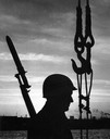
| Date: | 09 1958 |
|---|---|
| Description: | Silhouette of a guard patrolling while wearing a helmet and carrying a bayonet. |

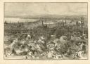
| Date: | 1937 |
|---|---|
| Description: | Bird's-eye view of Milwaukee in 1853 details building features and city layout from southwest. Important buildings are numbered in a silhouette drawing bel... |
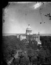
| Date: | |
|---|---|
| Description: | Elevated view of the third Wisconsin Capitol as originally constructed. The trees of the Capitol Park are already so large that they largely obscure any vi... |

| Date: | 1900 |
|---|---|
| Description: | Cyanotype print of Winnequah on Lake Monona with small buildings and three platforms for swings. A note on the back of the print reads: "The high swing was... |

| Date: | 1929 |
|---|---|
| Description: | Bird's-eye map of the University of Wisconsin-Madison on Lake Mendota. Black and white drawing with named streets and numbered buildings without location ... |
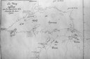
| Date: | 1671 |
|---|---|
| Description: | Photostat of map of Lac Tracy Ou Superieur (Lake Superior). Portions of Lac des Illinois (Lake Michigan) and Lac des Hurons (Lake Huron) are also shown. Gr... |
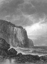
| Date: | 1873 |
|---|---|
| Description: | Drawing of the entrance to Baptism Bay on Lake Superior. |

| Date: | 09 08 1956 |
|---|---|
| Description: | A young man launches his toy sailboat in the lagoon. |
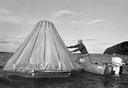
| Date: | 1950 |
|---|---|
| Description: | A man sets up a cone-shaped instrument designed to distill fresh water from salt water as he leans out of a small motor boat on the water. |
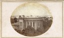
| Date: | 1861 |
|---|---|
| Description: | East (King Street) wing of the third Wisconsin State Capitol and the south wall of the Territorial Capitol (at the left) taken from the roof of the buildin... |
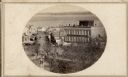
| Date: | 1860 |
|---|---|
| Description: | Intersection of King and East Main streets photographed by John S. Fuller from the Wisconsin State Capitol roof, about 1860-1863. In the foreground two st... |
If you didn't find the material you searched for, our Library Reference Staff can help.
Call our reference desk at 608-264-6535 or email us at: