Filter: Categories of Wisconsin Historical Images
Filter: Subject of Land
Filter: County of Lincoln
Filter: Categories of Wisconsin Historical Images
Filter: Subject of Land
Filter: County of Lincoln

| Date: | 1943 |
|---|---|
| Description: | A map that shows the lands for sale by the Tomahawk Land Company of Tomahawk, Wisconsin, in the counties of Langlade, Lincoln, Oneida, and Price. The map s... |

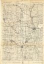
| Date: | 1915 |
|---|---|
| Description: | This 1915 map of Lincoln County, Wisconsin, shows the township and range grid, towns, cities and villages, lakes and streams, residences, churches, school ... |

| Date: | 1926 |
|---|---|
| Description: | A map of Lincoln County, Wisconsin that shows the township and range grid, towns, cities and villages, lakes and streams, residences, churches, school hous... |
| Date: | 1872 |
|---|---|
| Description: | Shows what is currently Lincoln County and portions of Vilas, Oneida, Iron, and Langlade counties. Includes manuscript annotations of marked land tracts. |

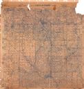
| Date: | |
|---|---|
| Description: | The top section of a map of Lincoln County. |

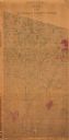
| Date: | |
|---|---|
| Description: | The middle section of a map of Lincoln County. |

| Date: | |
|---|---|
| Description: | The bottom section of a map of Lincoln County. |

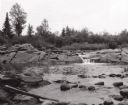
| Date: | 1900 |
|---|---|
| Description: | Photographic postcard view up the Wisconsin River near the foot of Grandfather Falls, which falls 90 feet in 1 1/2 miles. Caption reads: "Near the foot of ... |
| Date: | 1940 |
|---|---|
| Description: | This quadrangle collection of maps, meaning geological surveys, shows sections of central and northern Wisconsin. The maps include a quadrangle index map. ... |
| Date: | 1900 |
|---|---|
| Description: | This map shows areas of Merrill, Corning, Scott, Rock Falls, Russel, Pelisan, Pine River, Ackley, and the Wisconsin River. The left margin of the map inclu... |

| Date: | 1902 |
|---|---|
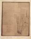
| Description: | A plat map of Lincoln County showing Township 34 North, Range 8 East. |

| Date: | 1906 |
|---|---|
| Description: | A photocopy of the T.35N, R-8E portion of a map of Lincoln County. |

| Date: | |
|---|---|
| Description: | A photocopy of the T.34N, R.8E portion of a map of Lincoln County. |
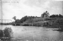
| Date: | 1907 |
|---|---|
| Description: | View across water towards a large Queen Anne style house sitting on a hill above the Wisconsin River. There is a bridge on the left and a road, now South C... |

| Date: | 1901 |
|---|---|
| Description: | A Sanborn map of Tomahawk featuring the Bay Mill Company's lumber yard. |

| Date: | 04 1971 |
|---|---|
| Description: | View across river towards a snowy shoreline along the Prairie River. |

| Date: | 1907 |
|---|---|
| Description: | Text on front reads: "Train of House Boats, at Tomahawk, Wis." A train of four houseboats in the water with another boat to pull them. Five rowboats are in... |
If you didn't find the material you searched for, our Library Reference Staff can help.
Call our reference desk at 608-264-6535 or email us at: