 Filter: Categories of Wisconsin Historical Images
Filter: Subject of Land
Filter: County of Sheboygan
Filter: Categories of Wisconsin Historical Images
Filter: Subject of Land
Filter: County of Sheboygan

| Date: | 1885 |
|---|---|
| Description: | Bird's-eye view of Sheboygan, with inset of J.J. Volrath Manufacturing Company. |
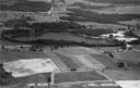
| Date: | 1947 |
|---|---|
| Description: | Aerial view of Lake Seven, surrounded by trees. Agricultural fields fill the foreground. Another lake is in the upper right. Caption reads: "Lake Seven Ade... |
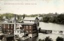
| Date: | 1910 |
|---|---|
| Description: | Elevated view of the White Wagon Works and Rock Mills. Caption reads: "White Wagon Works and Rock Mills, Sheboygan Falls, Wis." |
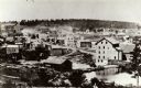
| Date: | 1868 |
|---|---|
| Description: | A view taken from the elevation on the south side of the Mullet River. |
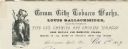
| Date: | |
|---|---|
| Description: | Letterhead of Louis Ballschmider of the Cream City Tobacco Works of Sheboygan Falls, Wisconsin, manufacturer of and dealer in various tobacco products. On ... |

| Date: | 1977 |
|---|---|
| Description: | This 1977 map identifies the locations of 100 cemeteries in Sheboygan County, Wisconsin. Cemeteries are listed by town. |

| Date: | 1862 |
|---|---|
| Description: | This 1862 map of Sheboygan County, Wisconsin, shows land ownership and acreages, the township and range grid, towns, cities and villages, roads, railroads,... |

| Date: | 1934 |
|---|---|
| Description: | This 1930s highway map of Sheboygan County, Wisconsin, shows roads, the township and range grid, towns, sections, cities and villages, and streams, lakes, ... |

| Date: | 1906 |
|---|---|
| Description: | This map of Sheboygan County, Wisconsin, from the early 20th century shows school districts and school locations in the county. Also shown are the township... |

| Date: | 1972 |
|---|---|
| Description: | This map of Sheboygan County, Wisconsin, shows the location of churches in the county. Churches are indexed for each town. Also shown are sections, cities ... |

| Date: | 1898 |
|---|---|
| Description: | This map shows the contour depths of Elkhart Lake in the Town of Rhine, Sheboygan County, Wisconsin, and includes two cross sections of the lake. The villa... |
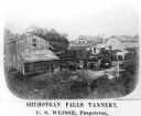
| Date: | 1878 |
|---|---|
| Description: | Elevated view of several buildings making up the Sheboygan Falls Tannery, which was owned by proprietor C.S. Weisse. Weisse is at the far right, standing w... |

| Date: | 1862 |
|---|---|
| Description: | Shows townships and sections, landownership and acreage, roads, railroads, churches, schools, and cemeteries. Inset maps: Plat of Hingham -- Plat of Casca... |
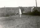
| Date: | 1931 |
|---|---|
| Description: | Lorena Feldmann, 13, hoes in the garden at her family's farm. She is somewhat overdressed for the task in a light coat, white stockings and dress shoes. A ... |

| Date: | 1840 |
|---|---|
| Description: | This is a plat map of Sheboygan showing the Sheboygan River and Lake Michigan. Streets are labeled and plats are numbered in quadrants. Some points of inte... |
| Date: | 1900 |
|---|---|
| Description: | This map shows the paper city situated at the mouth of the Memee (Pigeon) River in Sheboygan County, just north of Sheboygan. Land parcels, streets, and ri... |
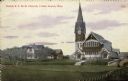
| Date: | 03 03 1910 |
|---|---|
| Description: | Hand-colored view of the Dutch R.F.M.D. Church. View across field or lawn. There is a dwelling and stable to the left of the church, and another building i... |
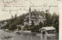
| Date: | 1907 |
|---|---|
| Description: | Colorized elevated view of a large lakeside hotel inspired by castles on the Rhine. A small excursion boat is passing the dock and boathouse. Caption reads... |

| Date: | |
|---|---|
| Description: | Elevated view of the expansive Kohler Plant and surrounding landscape. Caption reads: "Bird's-Eye View of Kohler Plant, Kohler, Wis." |

| Date: | 10 1978 |
|---|---|
| Description: | Two men are standing on the rocky shoreline of the Sheboygan River. One man is holding a shovel in his right hand and a glass jar in his left hand. The oth... |
If you didn't find the material you searched for, our Library Reference Staff can help.
Call our reference desk at 608-264-6535 or email us at: