 Filter: Categories of Wisconsin Historical Images
Filter: Subject of Land
Filter: County of Winnebago
Filter: Categories of Wisconsin Historical Images
Filter: Subject of Land
Filter: County of Winnebago
| Date: | 1932 |
|---|---|
| Description: | In order to undertake a trans-Atlantic flight to Norway, Clyde Allen Lee sought financial support from the local Oshkosh clothing company. The sign painted... |
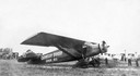
| Date: | 1923 |
|---|---|
| Description: | The hangar and three airplanes (a Canuck and a J-1 Standard) at the airport operated by the Larson Brothers of Larsen, Wisconsin. The field was both the mo... |
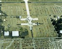
| Date: | 1988 |
|---|---|
| Description: | Aerial view of the 1988 EAA (Experimental Aviation Association) Convention and Fly-in at Wittman Field. On the ground is the Concorde and a B-1 Bomber. |
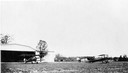
| Date: | 09 29 1963 |
|---|---|
| Description: | The Menasha Woodenware plant and water tower on Doty Island from across the Fox River canal, with a small railroad dolly in the foreground. |
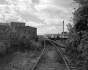
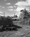
| Date: | 09 29 1963 |
|---|---|
| Description: | View down railroad tracks towards the railroad bridge, with industrial plants on Doty Island. |
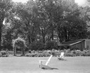
| Date: | 06 16 1963 |
|---|---|
| Description: | Garden, entrance to swimming pool, and pavilion at the Donald Shepard residence, originally the Smith house, built by the son of the founder of the Menasha... |

| Date: | 1833 |
|---|---|
| Description: | Map of part of the military road from Fort Crawford to Fort Howard. "Recorded on pages 668.669 Book B." Surveyed by Lieut. Center. Scale: 2 miles = 1 inch. |
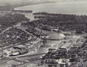
| Date: | 1955 |
|---|---|
| Description: | Aerial view of "the island" with the Marathon Corporation paper mills. The Fox River flowing out of Lake Winnebago separates the two cities, Neenah and Men... |
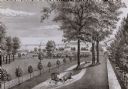
| Date: | |
|---|---|
| Description: | A drawing from Harney's "History of Winnebago County" of E.L. Mathewson's home on Doty Island. |

| Date: | 1840 |
|---|---|
| Description: | This map surveyed under the direction of Captain Thomas J. Cram is one in a series of seventeen that accompanied Cram's report on the Fox-Wisconsin river s... |

| Date: | 1910 |
|---|---|
| Description: | Doty's Loggery. Caption printed under image reads: "Governor James Duane Doty, in 1845, built this log house on Doty's Island (Menasha), and resided there ... |

| Date: | |
|---|---|
| Description: | Captain John Henry Otto, (marked with X), along with another man from the 21st Wisconsin Infantry, posing on the top of Lookout Mountain, Tennessee. John H... |

| Date: | 1875 |
|---|---|
| Description: | This map, from G.K. Warren's 1876 Report on the transportation route along the Wisconsin and Fox rivers in the State of Wisconsin between the Mississippi R... |
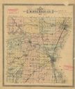
| Date: | |
|---|---|
| Description: | Map shows townships, roads and railroads, churches, schools, and selected buildings and property owners. |

| Date: | 1712 |
|---|---|
| Description: | This drawing, based on an 1897 survey, appeared in the 1899 Proceedings of the State Historical Society of Wisconsin, accompanying Publius V. Lawson's arti... |

| Date: | 03 1911 |
|---|---|
| Description: | This 1911 topographic map shows Lake Winnebago and the surrounding area. The township and range grid, counties, towns, sections, cities, villages and post ... |

| Date: | 1855 |
|---|---|
| Description: | This 1855 map of Winnebago County, Wisconsin, shows the township and range grid, towns, cities, villages, and post offices, roads, and lakes and streams. |

| Date: | 1897 |
|---|---|
| Description: | This 1897 map of Winnebago County, Wisconsin, shows the township and range grid, towns, sections, cities and villages, landownership and acreages, rural re... |
If you didn't find the material you searched for, our Library Reference Staff can help.
Call our reference desk at 608-264-6535 or email us at:

