 Filter: Categories of Wisconsin Historical Images
Filter: Subject of Land companies
Filter: Creator Name of Unknown
Filter: Categories of Wisconsin Historical Images
Filter: Subject of Land companies
Filter: Creator Name of Unknown
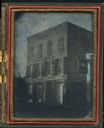
| Date: | 1855 |
|---|---|
| Description: | Quarter plate ambrotype of a brick structure, possibly in Green Bay, Wisconsin, housing the office of J.S. Baker, Land Agent. The building is three stories... |
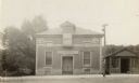
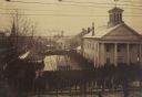
| Date: | 1925 |
|---|---|
| Description: | The Knights of Pythias Castle Hall, formerly the Presbyterian Church, dedicated in 1844. The small building to the right of the church was built and occupi... |
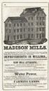
| Date: | 1851 |
|---|---|
| Description: | Engraving of the five-story tall mill erected at the outlet of the Yahara Creek by Leonard J. Farwell. This engraving appears in Statistics of Dane County,... |
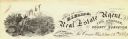
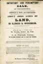
| Date: | 1855 |
|---|---|
| Description: | Advertisment of Leonard J. Farwell from the 1855 Madison City Directory for the real estate property he had for sale. At the time Farwell was the largest ... |
| Date: | |
|---|---|
| Description: | Letterhead of Baldwin & Killen Lands and W.H. Killen & Company, dealers of farm, lumber, and mineral lands, from Appleton, Wisconsin, with an image on the ... |

| Date: | 1900 |
|---|---|
| Description: | A map of Wisconsin, eastern Minnesota and Iowa, northern Iowa, and Michigan’s Upper Peninsula, showing railway lines, with those marked with heavy red line... |
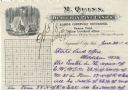
| Date: | |
|---|---|
| Description: | Letterhead of John J. Sherman, a real estate broker and tax, title, collection, and passenger agent in Wausau, Wisconsin, with images of men felling trees ... |
| Date: | |
|---|---|
| Description: | Letterhead of H.I. Bliss, a real estate agent, civil engineer, and county surveyor in La Crosse, Wisconsin. On the left a group of three men are surveying ... |
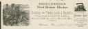
| Date: | |
|---|---|
| Description: | Letterhead of M. Quinn, "Dealer in Pine Lands," with two men in front of a tent at a campsite, one of whom is cooking over a campfire and the other is sitt... |
| Date: | 12 18 1890 |
|---|---|
| Description: | Elevated view looking down at homestead applicants waiting in line for 2-3 days in winter cold before a window in the Marathon County Court House, Dec. 18-... |

| Date: | 1836 |
|---|---|
| Description: | This map of Belmont includes notarization from the justice of the peace of Iowa County, May 15, 1836, acknowledging John Atchison as proprietor of Belmont ... |

| Date: | |
|---|---|
| Description: | Postcard advertising the Good Land Company with a photograph of a farm and information for "Homeseekers, Farmers and Investors." |
| Date: | 04 1848 |
|---|---|
| Description: | Poster advertising an auction for about 49,000 acres of land for sale in Wisconsin and Illinois by Thomas & Sons Auctioneers. |
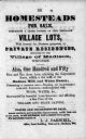
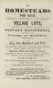
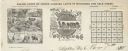
| Date: | 1855 |
|---|---|
| Description: | Poster advertising homesteads and village lots for sale. |

| Date: | 1874 |
|---|---|
| Description: | This map shows townships and sections, post offices, roads, and railroads. The left margin reads: "For sale at Cushing Land Agency, St. Croix Falls, Wis. 4... |

| Date: | 1891 |
|---|---|
| Description: | This blueprint manuscript map shows land owned by Green Bay & Mississippi Canal Co., Meade, Vilas, Patten, and Hewitt. Streets and the Fox River are labele... |

| Date: | 1790 |
|---|---|
| Description: | An ink and hand-colored map, showing the land and landowners of the Susquehanna company purchase in Pennsylvania. Rivers are shown and occasionally labeled... |

| Date: | |
|---|---|
| Description: | A photocopy of the T.34N, R.8E portion of a map of Lincoln County. |

| Date: | 1901 |
|---|---|
| Description: | A plat map of Marathon county, 28 township, north range, 7 east. |

| Date: | 1901 |
|---|---|
| Description: | A plat map of Marathon county, township 28, north range, 8 east. |
If you didn't find the material you searched for, our Library Reference Staff can help.
Call our reference desk at 608-264-6535 or email us at: