 Filter: Categories of Wisconsin Historical Images
Filter: Subject of Landforms
Filter: Creator Name of Unknown
Filter: Categories of Wisconsin Historical Images
Filter: Subject of Landforms
Filter: Creator Name of Unknown
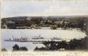
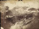
| Date: | 1905 |
|---|---|
| Description: | Elevated view of Lake Geneva Bay, with assorted homes and hotels, and boats docked at long piers. Caption reads: "Geneva Bay, Lake Geneva, Wis." |

| Date: | 1941 |
|---|---|
| Description: | Official highway map of Wisconsin, "the playground of the Midwest," showing the state transportation network prior to World War II. |

| Date: | 1856 |
|---|---|
| Description: | Isthmus of Madison, including Lake Mendota, or Great Lake, and Lake Menona [sic]. |

| Date: | 07 01 1836 |
|---|---|
| Description: | Original plat map of the town of Madison on the four lakes. |

| Date: | 1864 |
|---|---|
| Description: | Fort Crawford was decommissioned in 1856, having outlived its usefulness as a frontier post. During the Civil War, however, it functioned as a military ho... |

| Date: | 1673 |
|---|---|
| Description: | P. Marquette en Joliet, gedan in't jaar 1673. |
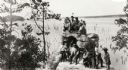
| Date: | 1920 |
|---|---|
| Description: | A group of Indians, probably Ho-Chunk, in traditional costume, posing on and around Demon's Anvil. |

| Date: | |
|---|---|
| Description: | Plan of the battle of the horse shoe bend on the East Pecatonica. |

| Date: | 1916 |
|---|---|
| Description: | Southeastern Wisconsin which lies east of Whitewater and south of Port Washington. |

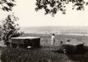
| Date: | 10 1905 |
|---|---|
| Description: | Elevated view from Reservoir Bluff to the east of the town. The bluffs of Iowa can be seen in the distance. |
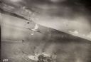
| Date: | 10 22 1943 |
|---|---|
| Description: | View across water of Mushu Island in the distance. There is a ship in the foreground, an airplane above, and the appearance of explosions in the water. |
| Date: | 1925 |
|---|---|
| Description: | Brisbois grave, tomb of Michael Brisbois. A woman is standing behind the graves, looking out to Prairie du Chien and the Mississippi River. |

| Date: | 1915 |
|---|---|
| Description: | Elevated view of Pontoon Bridge. Caption reads: "Largest Pontoon Bridge in the U.S. Scene at the Tri Cities, North and South McGergor and Prairie du Chien.... |

| Date: | 1950 |
|---|---|
| Description: | Elevated view of the bridge across the Mississippi River between Prairie du Chien, Wisconsin and Marquette, Iowa. Caption reads: "Suspension Bridge Between... |

| Date: | 1945 |
|---|---|
| Description: | An aerial view of the Portage Canal, Fox and Wisconsin Rivers. |
| Date: | |
|---|---|
| Description: | The Battle of Chattanooga from the Milwaukee-based American Panoramic Company's cyclorama "The Storming of Missionary Ridge." |

| Date: | 1935 |
|---|---|
| Description: | A student at Highlander having a picnic behind the school. |

| Date: | |
|---|---|
| Description: | View of a bridge at Fountain Bluff near Platteville. |
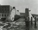
| Date: | 1913 |
|---|---|
| Description: | Looking across water and through the locks to a shoreline with a large hill in the background. A building is on the left, a wall and pilings are in the wat... |
If you didn't find the material you searched for, our Library Reference Staff can help.
Call our reference desk at 608-264-6535 or email us at:
