Filter: Categories of Wisconsin Historical Images
Filter: Subject of Log transportation
Filter: Year of 1800-1899
Filter: Categories of Wisconsin Historical Images
Filter: Subject of Log transportation
Filter: Year of 1800-1899

| Date: | 1870 |
|---|---|
| Description: | Bird's-eye map of Prairie du Sac. |

| Date: | 1870 |
|---|---|
| Description: | Sauk City is the oldest incorporated village in Wisconsin (incorporated in 1854) and also has the oldest organized volunteer fire department in the state, ... |

| Date: | 1874 |
|---|---|
| Description: | Bird's-eye map of Chippewa Falls. |

| Date: | 1872 |
|---|---|
| Description: | Birds-eye drawing of Eau Claire depicts street names and street locations, houses, trees, bridges, piers, canals, railroads, and the Chippewa and Eau Clair... |

| Date: | 1880 |
|---|---|
| Description: | Bird's-eye map over the Mississippi River of Fountain City. Paddle steamers and steamboats are on the river, and bluffs are in the background. |

| Date: | 1871 |
|---|---|
| Description: | Birds eye map of New London depicts street names and street locations, houses, trees, the bridge, Wolf River, and the bayou. At the bottom of the map, a re... |

| Date: | 1883 |
|---|---|
| Description: | Bird's-eye map of Prairie du Sac, Wisconsin with an inset of Clifton. |
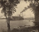
| Date: | 1885 |
|---|---|
| Description: | View from shoreline of the sternwheel steamer "E. Rutledge," owned by Weyerhaeuser & Denkmann's Rock Island Lumber Company, picking up a raft of logs at Be... |
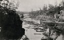
| Date: | 1886 |
|---|---|
| Description: | Elevated view of a log jam near the Dalles on the St. Croix River. Caption at bottom reads: "St. Croix Riv. and Bridge, St. Croix Falls." |

| Date: | 1872 |
|---|---|
| Description: | Map of the Chippewa River, from the head of navigation at the city of Chippewa Falls, covering a distance of 16 miles above : showing the established impro... |
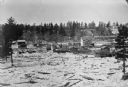
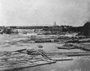
| Date: | 1876 |
|---|---|
| Description: | Town with logs overflowing the river into yards, probably the Ice Gorge of 1876. |
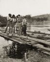
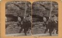
| Date: | 1886 |
|---|---|
| Description: | Stereograph of five men standing on a log and a plank of wood while another man is chopping at the log with an axe. |
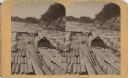
| Date: | 1886 |
|---|---|
| Description: | Stereograph of a man on the end of the raft as he prepares to pass through the water's rough rapids. |

| Date: | 1886 |
|---|---|
| Description: | Stereograph of photographer Henry Hamilton Bennett pulling an oar on a Wisconsin raft. |

| Date: | 1886 |
|---|---|
| Description: | Stereograph of photographer Henry Hamilton Bennett pulling an oar on a Wisconsin raft. |

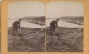
| Date: | 1886 |
|---|---|
| Description: | Stereograph of several men working at dusk, knee deep in water attending to the raft. |
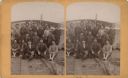
| Date: | 1886 |
|---|---|
| Description: | Stereograph of the raft's crew. |
| Date: | 1886 |
|---|---|
| Description: | Stereograph of a man as he rigs a rope around a log on a lumber raft. |
| Date: | 1886 |
|---|---|
| Description: | Stereograph of a group of men on a lumber raft holding a log vertical while other men push another log around it, creating a make-shift drill. |
If you didn't find the material you searched for, our Library Reference Staff can help.
Call our reference desk at 608-264-6535 or email us at: