 Filter: Categories of Wisconsin Historical Images
Filter: Subject of Maps
Filter: Type of Map or Atlas
Filter: Categories of Wisconsin Historical Images
Filter: Subject of Maps
Filter: Type of Map or Atlas

| Date: | 1983 |
|---|---|
| Description: | This map covers Vilas county as well as parts of Iron, Oneida, and Forest counties. Club trails are shown in dotted red lines and state trails are shown in... |

| Date: | 1994 |
|---|---|
| Description: | This map shows historical sites, picnic grounds, public boat landings, canoe and motor boat trips, and resort locations. The left margin of the map include... |

| Date: | 1974 |
|---|---|
| Description: | This map draws content from a map originally created by George Featherstongaugh in 1840. The map shows streets, land ownership, the Brotherton Indian reser... |

| Date: | 1937 |
|---|---|
| Description: | This map shows the major roads, cities, towns, lakes, and rivers of Wisconsin and some of the neighboring states. The front includes an add for Coca-Cola, ... |

| Date: | 1937 |
|---|---|
| Description: | This map shows the major cities, towns, highways, roads, lakes, and rivers of Wisconsin and some of the neighboring states. An index is included on the fro... |

| Date: | 01 01 1959 |
|---|---|
| Description: | This map shows many of the rivers, dams, bays, harbors, lakes, and canals. It includes an index of authorized federal project, both for navigation and floo... |

| Date: | 1941 |
|---|---|
| Description: | This map highlights the fishing district and shows labeled rivers, lakes, cities, county boundaries and points of interest. The map includes a list of trai... |

| Date: | 1958 |
|---|---|
| Description: | This map shows state public hunting and/or fishing grounds, national forests, state forests, county forests.The lower margin includes an index to these loc... |

| Date: | 1982 |
|---|---|
| Description: | This map shows the location of major settlement regions for various ethnic groups. Includes a legend in lower left hand corner. Sparse settlement is repres... |

| Date: | 1899 |
|---|---|
| Description: | This map shows color coded and numbered regions of Indian land cessions. Lake Superior and Lake Michigan are labeled and other lakes and rivers are shown. ... |

| Date: | 1878 |
|---|---|
| Description: | This lithograph shows Greenland, North America, Central America, South America, Polynesia, Australia, the Pacific Ocean, the Atlantic Ocean, the Arctic Oce... |

| Date: | 1878 |
|---|---|
| Description: | This lithograph shows Africa, Europe, Asia, Australia, and the Antarctic Continent, the Atlantic Ocean, the Indian Ocean, the Arctic Ocean, the Pacific Oce... |

| Date: | 1878 |
|---|---|
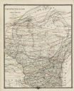
| Description: | This map shows 13 districts throughout the state. Congressional districts are outlined in red and judicial districts are outlined in blue as show borders a... |

| Date: | 1878 |
|---|---|
| Description: | This map shows geographic regions of the entire state. The bottom left corner includes an "Explanation of Color": Laurentien Granite (pink), Huronian Iron-... |
| Date: | 1878 |
|---|---|
| Description: | This map shows climate information for an entire year with an explanation key in the lower left corner of colors: Mean Temperature for the Year (red), Mean... |

| Date: | 1878 |
|---|---|
| Description: | This map shows ward boundaries in red, as well as counties, communities, rivers, lakes, Lake Michigan, and Lake Superior. The bottom left corner includes a... |

| Date: | 1911 |
|---|---|
| Description: | This map shows streets, railroads, the city house numbering system, and the Rock River. The left margin includes a street index. |
| Date: | 1878 |
|---|---|
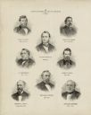
| Description: | This print shows eight former Governors of Wisconsin. In date order: "Louis P. Harvey, 1862 til April 20"; "Edward Salomon, April 20 1862-1864"; "James T. ... |

| Date: | 1890 |
|---|---|
| Description: | This map oriented with north towards the upper right shows sewers, cases of diphtheria and scarlet fever, schools, and public buildings. Lake Wingra is lab... |

| Date: | 1913 |
|---|---|
| Description: | This photocopy map shows plots with owners' names, land use both commercial and agricultural, and lot outlines on University land. Lake Mendota is labeled ... |
If you didn't find the material you searched for, our Library Reference Staff can help.
Call our reference desk at 608-264-6535 or email us at: