 Filter: Categories of Wisconsin Historical Images
Filter: Subject of Menominee Indians
Filter: Year of 1900-1999
Filter: Subject of transportation
Filter: Categories of Wisconsin Historical Images
Filter: Subject of Menominee Indians
Filter: Year of 1900-1999
Filter: Subject of transportation
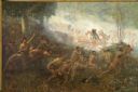
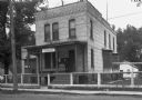
| Date: | 1903 |
|---|---|
| Description: | An important event of the French and Indian War (1754-1763) was commissioned in 1903 by Robert Laird McCormick, president of the State Historical Society o... |
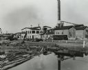
| Date: | 1950 |
|---|---|
| Description: | A sawmill run on the Menominee Indian Reservation. |
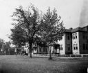
| Date: | 1936 |
|---|---|
| Description: | St. Joseph's Indian School on the Keshena Menominee Reservation. |
| Date: | 1933 |
|---|---|
| Description: | Native Americans hired to assist with the White Pine Blister Rust eradication effort on the Menominee Reservation are being trucked to their work site. |

| Date: | 1936 |
|---|---|
| Description: | Loading a large white pine log cut on the Menominee Indian Reservation onto a truck. The log was hauled to the Wisconsin State Fair for a display about the... |
| Date: | 1935 |
|---|---|
| Description: | U.S. Department of the Indian agency building on the Menominee Indian Reservation. |
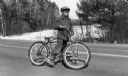
| Date: | 04 1954 |
|---|---|
| Description: | A young Menominee Indian (Charles ?) pauses briefly for a photograph while straddling his bicycle. He is stopped on the road with the snow-covered Wolf Riv... |
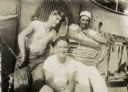
| Date: | 1917 |
|---|---|
| Description: | Candid portrait of three men in white t-shirts. Angus Lookaround, in a white hat, is seated, holding a tuba. The men appear to be aboard a ship, possibly t... |
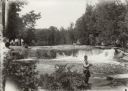
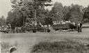
| Date: | 1929 |
|---|---|
| Description: | Group of people at Bear Trap Falls in the Wolf River near Keshena. People are standing on the shoreline on the left near a sign for the falls. A man is sta... |
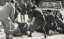
| Date: | 01 27 1975 |
|---|---|
| Description: | Members of the Wisconsin National Guard arrest a group of Native Americans during the takeover of the Alexian Brother Novitiate near Gresham. The arrest wa... |
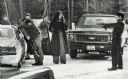
| Date: | 1975 |
|---|---|
| Description: | An unidentified member of the Wisconsin State Patrol points his revolver at several Native Americans at a vehicle checkpoint near Gresham. The State Patrol... |

| Date: | 1938 |
|---|---|
| Description: | This map shows lakes, rivers, roads, trails, lookout towers, and railroads. |

| Date: | 1900 |
|---|---|
| Description: | This map of shows the township grid, counties, cities and villages, lakes, rivers, rail lines and the Menominee Indian Reservation. |

| Date: | 1902 |
|---|---|
| Description: | This map shows the railroads of southern Wisconsin with the routes of the Chicago, Milwaukee, and St. Paul Railway traced in red. The township grid, counti... |

| Date: | 1910 |
|---|---|
| Description: | This map of northeastern Wisconsin shows the township grid, counties, cities and villages, lakes, rivers, rail lines and the Menominee Indian Reservation. ... |

| Date: | 09 17 1959 |
|---|---|
| Description: | A map of the Menominee Indian Reservation that shows the highways, different types of roads, rivers and streams in the area. |

| Date: | 1993 |
|---|---|
| Description: | A series of three maps showing the lands of the Menominee, the first of these three maps shows the present-day Menominee Indian Reservation. Highways and r... |

| Date: | 1933 |
|---|---|
| Description: | This map shows the township and range system, sections, cities and villages, schools, roads, railroads, and lakes and streams in Shawano County, which at t... |

| Date: | 1958 |
|---|---|
| Description: | Image is an outdoor portrait of a performer wearing a fringed vest, beaded necklace and headdress, and holding a small axe. Member of the Peavey Falls grou... |

| Date: | 1939 |
|---|---|
| Description: | This illustrated map shows counties, highways, rivers, roads, present and proposed state parks and forests, proposed state parkways, proposed state monumen... |
If you didn't find the material you searched for, our Library Reference Staff can help.
Call our reference desk at 608-264-6535 or email us at: