 Filter: Categories of Wisconsin Historical Images
Filter: Subject of Michigan, Lake
Filter: Subject of coasts
Filter: Categories of Wisconsin Historical Images
Filter: Subject of Michigan, Lake
Filter: Subject of coasts

| Date: | 1951 |
|---|---|
| Description: | This map is a survey of Lake Michigan and the section of Milwaukee that borders the lake. Map of land includes major streets, and landmarks near water. Rel... |
| Date: | 04 16 1963 |
|---|---|
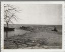
| Description: | Chaudoir Dock in Brussels. The shoreline is on the left and has rocks along its edge. In the background is Lake Michigan. |

| Date: | |
|---|---|
| Description: | Aerial view of harbors and bridge. Farm fields are on either side of the bridge. The city of Sturgeon Bay is in the distance. There are docks along the sho... |

| Date: | 1902 |
|---|---|
| Description: | This map is a chart of Milwaukee Harbor that displays local streets, bridges, roads, railroads, public buildings, businesses, factories, dry docks, parks, ... |

| Date: | 1777 |
|---|---|
| Description: | This detailed map of the American colonies shows cities, villages, roads, mountains, lakes, rivers, swamps, counties, state boundaries, and Native American... |

| Date: | 1690 |
|---|---|
| Description: | A mysterious mixture of mythology, ancient geography, and late 17th century knowledge of the American coastline. This map shows North and South America, bu... |

| Date: | 11 24 1781 |
|---|---|
| Description: | Map showing New York, New England, and south eastern Canada. Boundaries, ports, and a few cities are shown, but the map focuses on regions, Native American... |

| Date: | 1783 |
|---|---|
| Description: | Map of eastern Canada and part of America, with an inset map of the Great Lakes region in the lower left corner. It shows boundaries, cities, settlements, ... |

| Date: | 07 02 1920 |
|---|---|
| Description: | Alfred Holt is standing on the beach, carrying several boxes under his arm. To his right is his father W.A. Holt. A group of eight women are sitting on the... |
| Date: | 1962 |
|---|---|
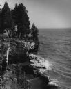
| Description: | Pine trees at the edge of the rocky shoreline in High Cliff Park on Lake Michigan. |
If you didn't find the material you searched for, our Library Reference Staff can help.
Call our reference desk at 608-264-6535 or email us at: