 Filter: Categories of Wisconsin Historical Images
Filter: Subject of Michigan, Lake
Filter: Subject of farms
Filter: Categories of Wisconsin Historical Images
Filter: Subject of Michigan, Lake
Filter: Subject of farms

| Date: | 1856 |
|---|---|
| Description: | The Ludemann's [also spelled Lueddemann] farm had been cultivated since the early 1850s by Mr. Ludemann, "a very pleasant Saxon with his very pleasant wife... |

| Date: | 1881 |
|---|---|
| Description: | A brochure with a map of Wisconsin that also includes information (in English, German, Norwegian, and Swedish) pertaining to the state, such as its timber ... |

| Date: | 1854 |
|---|---|
| Description: | Brightly-colored map exhaustively marks the townships, County Towns and villages of Wisconsin. It also shows rivers, canals, railroads, and plank roads. Ea... |

| Date: | 1855 |
|---|---|
| Description: | Drawn seven years after Wisconsin entered statehood, this map shows the counties, cities, towns, rivers and lakes in the entire state. The map includes a c... |

| Date: | 1912 |
|---|---|
| Description: | View down dirt road leading to the Carlson farm at Nelson Bay in Peninsula State Park. A man stands in the background among the farm buildings near a parke... |
| Date: | 1921 |
|---|---|
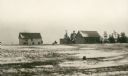
| Description: | View across snowy field of a shingled house, barn and other outbuildings standing empty near the shore of Lake Michigan at Newport Village. |

| Date: | 1912 |
|---|---|
| Description: | A plat map of the township of West Kewaunee. |
| Date: | 07 29 1946 |
|---|---|
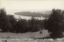
| Description: | Text on front reads: "Little Sister and Sister Bays, Sister Bay, Wis." A view from a hill of the shoreline of Green Bay, Lake Michigan. |
If you didn't find the material you searched for, our Library Reference Staff can help.
Call our reference desk at 608-264-6535 or email us at: