Filter: Categories of Wisconsin Historical Images
Filter: Subject of Michigan, Lake
Filter: Subject of human settlements
Filter: Categories of Wisconsin Historical Images
Filter: Subject of Michigan, Lake
Filter: Subject of human settlements

| Date: | 1856 |
|---|---|
| Description: | This map show the surveyed southern part of state and includes "profile of the Milwaukee and Mississippi Rail Road." Counties are shown in pink, green, blu... |

| Date: | 1886 |
|---|---|
| Description: | This map shows U.S. land offices, completed railroads, railroad land grant limits, lakes, rivers, and Indian reservations. Communities, lakes, and rivers a... |

| Date: | 1874 |
|---|---|
| Description: | This map shows lakes, rivers, state, county, and town boundaries, as well as railroads completed, in progress, and contemplated. The map includes a color d... |

| Date: | 1871 |
|---|---|
| Description: | Bird's-eye view of the Chicago fire of October 8, 1871. The hand-colored lithograph was published by Currier and Ives. |
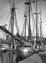
| Date: | |
|---|---|
| Description: | Leaving Milwaukee harbor via tugboat, this was the final voyage of the Lucia B. Simpson. Made in 1928, the Simpson was the last of the lake lumber s... |
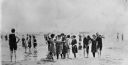
| Date: | 1910 |
|---|---|
| Description: | Popular bathing beaches like this one on Lake Michigan offered relief from the heat as well as the opportunity to be seen in the latest fashions of the 191... |

| Date: | 1848 |
|---|---|
| Description: | In 1849, northern Wisconsin was composed of huge sectional regions such as Chippewa, Portage, Brown and Crawford, whereas southern Wisconsin was constitute... |
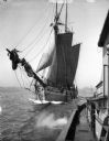
| Date: | |
|---|---|
| Description: | The screw ferry, Ann Arbor No. 7, at Frankfort. Later named Viking, then Viking I. Caption reads: "Frankfort, Mich." |
| Date: | 1859 |
|---|---|
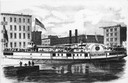
| Description: | Lithograph from Frank Leslie's Illustrated News of the sidewheel passenger, Lady Elgin, at her wharf in Chicago, Illinois in 1860. From a pho... |

| Date: | |
|---|---|
| Description: | A sketch of the sidewheel passenger, Lady Elgin, at her wharf in Chicago, Illinois. |
| Date: | |
|---|---|
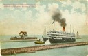
| Description: | The screw passenger excursion vessel, "Christopher Columbus," being towed into the Milwaukee harbor past a breakwater. Milwaukee North Pier Inner Light in ... |
| Date: | |
|---|---|
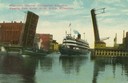
| Description: | Colorized view depicting the passenger excursion vessel, "Christopher Columbus," approaching the East Water Street Bridge. Caption reads: "Whaleback Steame... |

| Date: | 1853 |
|---|---|
| Description: | Bird's-eye map of Milwaukee looking east toward Lake Michigan from a bluff, long since graded into a slope, at about 6th Street between Wisconsin Avenue an... |

| Date: | |
|---|---|
| Description: | Map of the district of the Peshtigo fire, approximately 1,280,000 acres, in Wisconsin and Upper Michigan. |

| Date: | 1862 |
|---|---|
| Description: | Drawn the second year of the Civil War, this 1862 map of Milwaukee shows post offices, light houses, beacon lights, county buildings, elevator warehouses, ... |
| Date: | 1910 |
|---|---|
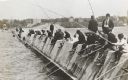
| Description: | Long row of men in suits and hats fishing on the breakwater. |
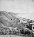
| Date: | 1877 |
|---|---|
| Description: | View of bluffs and buildings on the shore of Lake Michigan. |
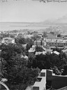
| Date: | |
|---|---|
| Description: | Elevated view south from Courthouse of rooftops, with harbor and bay in distance. |
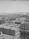
| Date: | |
|---|---|
| Description: | Milwaukee, towards South Point from Mitchell Block, E. Water Street and Michigan Street. Elevated view shows buildings and rooftops with bay and harbor in ... |
If you didn't find the material you searched for, our Library Reference Staff can help.
Call our reference desk at 608-264-6535 or email us at: