 Filter: Categories of Wisconsin Historical Images
Filter: Subject of Michigan, Lake
Filter: Subject of intellectual life
Filter: Categories of Wisconsin Historical Images
Filter: Subject of Michigan, Lake
Filter: Subject of intellectual life

| Date: | 1930 |
|---|---|
| Description: | This map shows the entire state plus portions of Illinois, Iowa, Minnesota, and Michigan outlined in blue. The map shows roads, state parks (black triangle... |

| Date: | 1920 |
|---|---|
| Description: | This map of the entire state shows state and other highways, cities, some lake, the Mississippi River, Lake Michigan, and Lake Superior. The bottom left co... |

| Date: | 1925 |
|---|---|
| Description: | The map shows the entire state with portions of Illinois, Iowa, Minnesota, and Michigan. The map shows concrete, gravel, all weather earth, clay, and sand ... |

| Date: | 1929 |
|---|---|
| Description: | This map shows the entire state of Wisconsin and Minnesota and portions of Illinois and Iowa. Counties, cities, highways, lakes, and rivers are labeled. Ro... |

| Date: | 1690 |
|---|---|
| Description: | A mysterious mixture of mythology, ancient geography, and late 17th century knowledge of the American coastline. This map shows North and South America, bu... |

| Date: | 1676 |
|---|---|
| Description: | Detailed map of North and South America. Cities, towns, forests, and mountains are shown pictorially. Duval labels regions, islands, cities, lakes, and Nat... |

| Date: | 1719 |
|---|---|
| Description: | Map of North America showing political boundaries, areas of Indian habitation, cities, towns, ports, rivers, mines, and other notable for North America fro... |

| Date: | 1683 |
|---|---|
| Description: | Map of the north east coast of North America showing islands, regions, Native American land, bays, and a few European settlements. The Great Lakes appear i... |

| Date: | 1777 |
|---|---|
| Description: | Map of Colonial America east of Lake Michigan showing regions, cities, forts, Native American land, mountains, lakes, and rivers. Crossed swords and small ... |
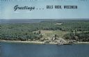
| Date: | |
|---|---|
| Description: | A color aerial view of Gills Rock from Green Bay. Washington Island and Lake Michigan are along the horizon. An excursion boat is docked at the landing. Ca... |

| Date: | 08 10 2008 |
|---|---|
| Description: | Underwater view of the wrecked scow schooner Silver Lake. The ship remains largely intact, but it is split in half where it was run over by the P... |
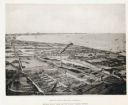
| Date: | 1892 |
|---|---|
| Description: | Bird's-eye view of Cudahy showing stock yards and the Cudahy packing houses. A train runs through the center of the image on the Chicago & Northwestern Rai... |

| Date: | 08 12 2018 |
|---|---|
| Description: | Underwater view of abandoned fishing nets covering the port side bow of the schooner Island City. |
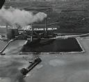
| Date: | 05 12 1959 |
|---|---|
| Description: | Aerial view of a large ship with a considerable amount of dark smoke coming from the rear. The ship appears to be heading toward a large field of coal buil... |

| Date: | 08 2007 |
|---|---|
| Description: | View from below of an archaeologist diving toward the wreckage of the Appomattox. |

| Date: | 08 2007 |
|---|---|
| Description: | View of the bottom, or bilge, of the Appomattox. The bilge was made entirely of wood, as on shipbuilder James Davidson’s other steamers. The heavy k... |

| Date: | 08 2007 |
|---|---|
| Description: | An archaeologist investigates floor keelsons near the bow of the Appomattox. |

| Date: | 08 2007 |
|---|---|
| Description: | View of steel plating lining the central keelson on the wreckage of the Appomattox. |

| Date: | 2010 |
|---|---|
| Description: | A large school of alewives swimming near the wreckage of a ship in Lake Michigan. |

| Date: | 08 2003 |
|---|---|
| Description: | View of the gear and shaft of the Kate Kelly at the bottom of Lake Michigan. |
If you didn't find the material you searched for, our Library Reference Staff can help.
Call our reference desk at 608-264-6535 or email us at: