Filter: Categories of Wisconsin Historical Images
Filter: Subject of Michigan, Lake
Filter: Subject of michigan, lake
Filter: Year of 1900-1999
Filter: Year of 1930-1939
Filter: Categories of Wisconsin Historical Images
Filter: Subject of Michigan, Lake
Filter: Subject of michigan, lake
Filter: Year of 1900-1999
Filter: Year of 1930-1939

| Date: | 1930 |
|---|---|
| Description: | Page 8 of the 1930 schedule is a map of the routes of the Goodrich Steamship Lines in Lake Michigan and Lake Huron. |
| Date: | 1931 |
|---|---|
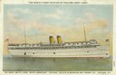
| Description: | Chicago, Duluth and Georgian Bay Transit Co. of Chicago, Illinois' screw passenger cruise vessel, "South American." |

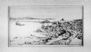
| Date: | 1937 |
|---|---|
| Description: | Bird's-eye view of Milwaukee in 1853 details building features and city layout from southwest. Important buildings are numbered in a silhouette drawing bel... |
| Date: | 1933 |
|---|---|
| Description: | View from Outer Lake Shore Drive looking south from Foster Avenue. Lake Michigan and the Chicago skyline are in the background. |
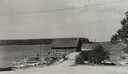
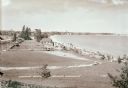
| Date: | 1936 |
|---|---|
| Description: | Crescent Beach campsite with cabins and miniature golf course by Lake Michigan. |
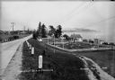
| Date: | 1935 |
|---|---|
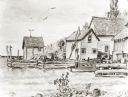
| Description: | View down road towards boats docked at the fishing wharf at Ephraim in Door County. The bluff on the horizon is in Peninsula State Park. |

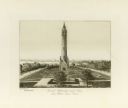
| Date: | 1932 |
|---|---|
| Description: | View of Lake Michigan from Memorial Hall. Caption reads: "Lake Michigan from Memorial Hall, Racine, Wisconsin". |
| Date: | 01 09 1933 |
|---|---|
| Description: | Bird's eye view of International Harvester's exhibit building at the "A Century of Progress" world's fair in Chicago. The shore of Lake Michigan is on the ... |
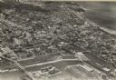
| Date: | 1938 |
|---|---|
| Description: | Aerial view of rivers, with Lake Michigan in upper right, train yards, and highway in lower left. |
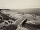
| Date: | 1930 |
|---|---|
| Description: | Elevated view of Lincoln Memorial Drive at the point where it joins Wisconsin Avenue, now the site of the Milwaukee County War Memorial Center. Lake Michig... |
| Date: | 1937 |
|---|---|
| Description: | View down the hill toward the U.S. Coast Guard Station on the left with two communications towers on the Lake Michigan shoreline. Railroad tracks are just ... |

| Date: | 1932 |
|---|---|
| Description: | This map includes a distance table, text, and insets maps of, Superior, Ashland, Marinette, Green Bay, Appleton, Manitowoc, Oshkosh, Fond Du Lac, Janesvill... |
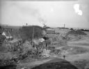
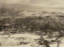
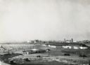
| Date: | 10 28 1938 |
|---|---|
| Description: | Elevated view of a cluster of old dwellings in the center, with broken shacks and rusted cars. In the background are railroad cars, and an industrial area ... |
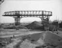
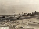
| Date: | 10 28 1938 |
|---|---|
| Description: | Men working near large dredge on Jones Island. Large piles of material are on the ground below the dredge. There is a ship on the right. In the distance a... |
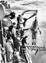
| Date: | 04 10 1937 |
|---|---|
| Description: | On April 10th, 1937, Max Nohl (shown in the dive suit) along with John Craig made a dive on the shipwreck Norland in order to perform another early ... |
| Date: | 1936 |
|---|---|
| Description: | Elevated view of Crescent Beach, with campsite with cabins and miniature golf course and other outbuildings. Downtown buildings can be seen in the backgrou... |
If you didn't find the material you searched for, our Library Reference Staff can help.
Call our reference desk at 608-264-6535 or email us at: