 Filter: Categories of Wisconsin Historical Images
Filter: Subject of Michigan, Lake
Filter: Year of 1800-1899
Filter: Year of 1860-1869
Filter: Categories of Wisconsin Historical Images
Filter: Subject of Michigan, Lake
Filter: Year of 1800-1899
Filter: Year of 1860-1869
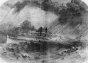
| Date: | 09 22 1860 |
|---|---|
| Description: | Sketch from the "New York Illustrated News" of the sinking of the sidewheel passenger, Lady Elgin. She was struck and sunk by the Augusta on ... |

| Date: | 1862 |
|---|---|
| Description: | Drawn the second year of the Civil War, this 1862 map of Milwaukee shows post offices, light houses, beacon lights, county buildings, elevator warehouses, ... |
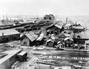
| Date: | 1865 |
|---|---|
| Description: | Elevated view of the first Milwaukee railroad depot, which was used by the Milwaukee & Waukesha and the Milwaukee & Mississippi railroads. The Milwaukee &... |

| Date: | 1865 |
|---|---|
| Description: | Map showing the location of meteorological stations and effects that Lake Michigan has had on Wisconsin temperatures in January and July. The map shows cou... |

| Date: | 1868 |
|---|---|
| Description: | Showing the counties, towns and railroads. Partly colored. Scale: 1 inch = 20 miles. |

| Date: | 1861 |
|---|---|
| Description: | A map of Wisconsin showing cities, counties, major roads, railroads, and bodies of water. Includes an inset of the vicinity of Milwaukee. |

| Date: | 1868 |
|---|---|
| Description: | Elevated view over rooftops looking towards Lake Michigan shoreline. Seaman's Furniture and Rooms building is surrounded by other commercial buildings. The... |
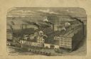
| Date: | 1868 |
|---|---|
| Description: | Engraved illustration of an elevated view of the "McCormick Reaper & Mower Works." Ships are on Lake Michigan in the background. |
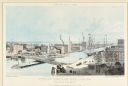
| Date: | 1861 |
|---|---|
| Description: | Lithograph illustration of downtown Chicago near the Rush Street bridge (a "swing bridge"). The McCormick Reaper Works and other factory buildings are on t... |

| Date: | 1860 |
|---|---|
| Description: | This colored map shows railroad lines east of the Mississippi as well as in the states bordering the Mississippi River. The Great Lakes and Gulf of Mexico ... |

| Date: | 1860 |
|---|---|
| Description: | A map of Wisconsin showing the railroads, rivers, counties, cities, villages, and named towns in the state, as well as the township grid for the portion of... |

| Date: | 1860 |
|---|---|
| Description: | A hand-drawn, ink on cloth map of southeastern Wisconsin that show roads and railroads that connect Chicago to Milwaukee and other towns in the southeaster... |

| Date: | 1860 |
|---|---|
| Description: | A survey map of Wisconsin, southeastern Minnesota, and northern Iowa, showing the status of surveys, rivers, and lakes. The map also shows the locations of... |

| Date: | 1864 |
|---|---|
| Description: | A geological map of Wisconsin that shows the locations of different rock deposits such as limestone, sandstone, shale, plutonic and the Penokee Iron Range.... |

| Date: | 1868 |
|---|---|
| Description: | Wisconsin and parts of Michigan, Minnesota, Illinois and Iowa. It shows cities and towns, drainage, administrative boundaries and the railroad network with... |

| Date: | 1866 |
|---|---|
| Description: | This thematic shows the effects that Lake Michigan has had on Wisconsin mean temperatures in January and July. The map shows counties, some cities, rivers ... |

| Date: | 1866 |
|---|---|
| Description: | A pen on paper, hand-drawn and colored map of Wisconsin and Michigan, showing counties, cities and villages, rivers and lakes, as well as railroads are in ... |

| Date: | 1866 |
|---|---|
| Description: | A pen on paper, hand-drawn and colored map of Wisconsin and Michigan, showing counties, cities and villages, rivers and lakes, as well as railroads are in ... |

| Date: | 1867 |
|---|---|
| Description: | Map of the entire state indicates county boundaries outlined in red, cities of over 3000 inhabitants and county seats. It also marks rivers and lakes. |

| Date: | 1868 |
|---|---|
| Description: | This map of the entire state shows county boundaries outlined in red, cities of over 3000 inhabitants and county seats. It also marks rivers, lakes, railro... |
If you didn't find the material you searched for, our Library Reference Staff can help.
Call our reference desk at 608-264-6535 or email us at: