 Filter: Categories of Wisconsin Historical Images
Filter: Subject of Michigan, Lake
Filter: Year of 1800-1899
Filter: Year of 1870-1879
Filter: Categories of Wisconsin Historical Images
Filter: Subject of Michigan, Lake
Filter: Year of 1800-1899
Filter: Year of 1870-1879

| Date: | 1874 |
|---|---|
| Description: | This map shows lakes, rivers, state, county, and town boundaries, as well as railroads completed, in progress, and contemplated. The map includes a color d... |

| Date: | 1871 |
|---|---|
| Description: | Bird's-eye view of the Chicago fire of October 8, 1871. The hand-colored lithograph was published by Currier and Ives. |
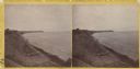
| Date: | 1877 |
|---|---|
| Description: | View of bluffs and buildings on the shore of Lake Michigan. |

| Date: | 1872 |
|---|---|
| Description: | Bird's-eye map of Milwaukee on Lake Michigan. |

| Date: | 1874 |
|---|---|
| Description: | Bird's-eye map of Racine, with an inset of Racine College. |

| Date: | 1879 |
|---|---|
| Description: | Bird's-eye map of Two Rivers. |
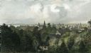
| Date: | 1872 |
|---|---|
| Description: | View of Milwaukee, looking southwest toward the county courthouse while it was under construction. |
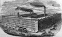
| Date: | 1875 |
|---|---|
| Description: | Drawing of the C.H. & L.J. McCormick Reaper Manufactory (McCormick Reaper Works). The factory was built after the Chicago Fire of 1871 destroyed the origin... |
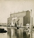
| Date: | 1870 |
|---|---|
| Description: | The Milwaukee & St. Paul Railway Company grain elevator at the Milwaukee harbor, with a sailing ship anchored nearby. |

| Date: | 1875 |
|---|---|
| Description: | The harbor piers and the entrance to the Sturgeon Bay ship canal. Men are standing on the shoreline. |

| Date: | 1876 |
|---|---|
| Description: | Made from U.S. Surveys and from minutes furnished by Jos. S. Buck and Dr. C. Chase. Scale 20 CHs to an inch. |
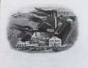
| Date: | 1875 |
|---|---|
| Description: | Elevated view of factory with lake and ships in the background. Trains, people, horses, and carriages, with a multitude of smokestacks in foreground. The f... |
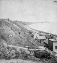
| Date: | 1870 |
|---|---|
| Description: | Stereograph; looking north from the end of Oneida Street along shoreline. |
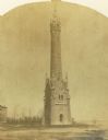
| Date: | 1870 |
|---|---|
| Description: | Water tower of the Milwaukee water works, North Point. |
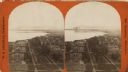
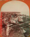
| Date: | 1876 |
|---|---|
| Description: | Stereograph. Elevated view looking roughly south, the foreground overlooks a residential neighborhood. On the far shoreline, smoke clouds spew out from lar... |
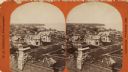
| Date: | 1876 |
|---|---|
| Description: | Stereograph of a view over rooftops of a neighborhood near Lake Michigan. Shoreline can be seen in the background. |
| Date: | 1876 |
|---|---|
| Description: | Stereograph of a view over rooftops of a neighborhood near Lake Michigan. Shoreline can be seen in the background. |

| Date: | 1878 |
|---|---|
| Description: | This map shows block numbers, wards, roads, railroads, parks, and selected buildings and includes a "Milwaukee city street guide" as well as a guide to pub... |
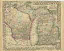
| Date: | 1870 |
|---|---|
| Description: | A hand-colored map of Wisconsin and Michigan detailing the states’ rivers, lakes, counties, town and cities. The map gives the greatest length, breadth, me... |
If you didn't find the material you searched for, our Library Reference Staff can help.
Call our reference desk at 608-264-6535 or email us at:
