 Filter: Categories of Wisconsin Historical Images
Filter: Subject of Military bases
Filter: Subject of mountains
Filter: Categories of Wisconsin Historical Images
Filter: Subject of Military bases
Filter: Subject of mountains

| Date: | 1944 |
|---|---|
| Description: | Two K-5 International trucks equipped with hoses and ladders used by the Camp Pendleton fire department are parked near a building and a road sign. The ori... |
| Date: | 1944 |
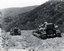
|---|---|
| Description: | Two men operate International crawler tractors (TracTracTors) with bulldozer blades on a rocky hillside as part of a military training program at Camp Pend... |
| Date: | 1944 |
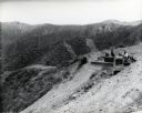
|---|---|
| Description: | A man uses an International crawler tractor (TracTracTor) equipped with a bulldozer blade on a hillside in the construction of a road. The original caption... |

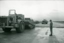
| Date: | 1967 |
|---|---|
| Description: | A man directs International pay scrapers along a runway at Phan Rang air force base in Vietnam. |
| Date: | 1967 |
|---|---|
| Description: | A man stands beside an International 270 pay scraper at Phan Rang, an air base in South Vietnam. |

| Date: | 11 30 1943 |
|---|---|
| Description: | Elevated view of the Rough Raider Squadron Laundry, serving 100 customers a day. Eight soldiers can be seen, some working, some watching, and one soldier c... |

| Date: | 01 13 1944 |
|---|---|
| Description: | Military trucks, jeeps and planes at the Lae Airstrip, New Guinea (present day Papua New Guinea). Lae was a Japanese occupied airstrip until September 16, ... |

| Date: | 1782 |
|---|---|
| Description: | Map of America east of the Mississippi River. It shows regions, state boundaries extending to the Mississippi River, cities, forts, Native American lands, ... |

| Date: | 1777 |
|---|---|
| Description: | Map of Colonial America east of Lake Michigan showing regions, cities, forts, Native American land, mountains, lakes, and rivers. Crossed swords and small ... |

| Date: | 1780 |
|---|---|
| Description: | Map of New York and parts of the neighboring states. It shows cities, forts, towns, roads, mountains, lakes, and rivers. several different boundary lines a... |

| Date: | 1780 |
|---|---|
| Description: | Detailed topographical and political map of the area from Lake Champlain to Albany and the Hudson River. Relief is shown through hachures. The map shows ci... |

| Date: | 1778 |
|---|---|
| Description: | Map of the land between Fort Ticonderoga and Albany. It shows cities, forts, mills, roads, mountains, swamps, waterfalls, lakes, and rivers. A few annotati... |

| Date: | 10 1776 |
|---|---|
| Description: | Broadside map showing the British invasion of New York city in August and September of 1776. The map shows important cities, forts, roads, hills, mountains... |

| Date: | 1756 |
|---|---|
| Description: | Map of Pennsylvania, showing cities, towns, roads, trading paths, portages, forts, mountains, swamps, waterfalls, lakes, and rivers. The map further includ... |

| Date: | 1781 |
|---|---|
| Description: | Map of North and South Carolina and Virginia towards the end of the Revolutionary War. It shows borders, counties, cities, court houses, bridges, chapels, ... |

| Date: | 1762 |
|---|---|
| Description: | Map of Virginia and parts of Maryland. It shows borders, boundary lines, Native American tribes and land, towns, forts, roads, mountains, waterfalls, bays,... |

| Date: | 1779 |
|---|---|
| Description: | Map of North Carolina showing counties, cities, towns, chapels, courthouses, Quaker meeting houses, forts, mountains, swamps, inlets, lakes, and rivers. A ... |

| Date: | 1779 |
|---|---|
| Description: | Map of colonial Georgia showing cities, towns, Native American land and towns, forts, roads, trading paths, islands, mountains, swamps, and rivers. Annotat... |

| Date: | 1781 |
|---|---|
| Description: | Map of the Southeastern part of the British Colonies in North America, Gulf Coast and Caribbean. It illustrates the of the Spanish and English fleets, part... |

| Date: | 1720 |
|---|---|
| Description: | Map showing the course of the Mississippi River from the Gulf of Mexico up past Lake Superior into Canada. It shows the towns, Native American tribes and l... |
If you didn't find the material you searched for, our Library Reference Staff can help.
Call our reference desk at 608-264-6535 or email us at: