 Filter: Categories of Wisconsin Historical Images
Filter: Subject of Mississippi River
Filter: Subject of intellectual life
Filter: Community of Prairie du Chien
Filter: Categories of Wisconsin Historical Images
Filter: Subject of Mississippi River
Filter: Subject of intellectual life
Filter: Community of Prairie du Chien

| Date: | 1870 |
|---|---|
| Description: | During the War of 1812, the only battle fought in Wisconsin was in Prairie du Chien, in 1814. Made fifty-six years later, this birds eye drawing depicts th... |

| Date: | 1884 |
|---|---|
| Description: | Bird's-eye view drawing of the grounds of Villa Louis, the estate of the fur trading Dousman family. After the death of H. Louis Dousman's mother in 1882, ... |
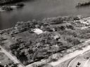
| Date: | 1960 |
|---|---|
| Description: | Aerial view of Villa Louis on the Mississippi River, and adjacent buildings. |
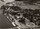
| Date: | 1958 |
|---|---|
| Description: | Aerial view of town. A bridge over the Mississippi River is in the foreground. |
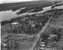
| Date: | 03 28 1949 |
|---|---|
| Description: | Aerial view of Prairie du Chien showing the Mississippi River in the background. |
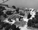
| Date: | |
|---|---|
| Description: | Aerial view of the Prairie du Chien plant of Oscar Mayer & Co. |

| Date: | 1839 |
|---|---|
| Description: | This map shows the geological makeup of the valley in red, yellow, and green, the Mississippi River, and the location of Fort Crawford. The geology on the ... |
| Date: | |
|---|---|
| Description: | Elevated view of Fort Crawford facing west showing north row of buildings. The Mississippi River is in the background. Typewritten caption reads: "Fort Cra... |
If you didn't find the material you searched for, our Library Reference Staff can help.
Call our reference desk at 608-264-6535 or email us at: