 Filter: Categories of Wisconsin Historical Images
Filter: Subject of Mississippi River
Filter: Subject of intellectual life
Filter: Year of 1800-1899
Filter: Categories of Wisconsin Historical Images
Filter: Subject of Mississippi River
Filter: Subject of intellectual life
Filter: Year of 1800-1899

| Date: | 1870 |
|---|---|
| Description: | During the War of 1812, the only battle fought in Wisconsin was in Prairie du Chien, in 1814. Made fifty-six years later, this birds eye drawing depicts th... |

| Date: | 1803 |
|---|---|
| Description: | Cours du Mississippi : comprenant la Louisiane, les 2 Florides, une partie des Etats-Unis, et pays adjacents. |

| Date: | 1880 |
|---|---|
| Description: | Alma was platted and settled in 1855, on a narrow strip of land between high bluffs and the Mississippi River. Its location made it a popular shipping cent... |

| Date: | 1867 |
|---|---|
| Description: | Bird's-eye map of La Crosse with nine insets of residences, schools, and the Court House and Jail. |

| Date: | 1873 |
|---|---|
| Description: | Bird's-eye map of La Crosse from the Mississippi River. |

| Date: | 1887 |
|---|---|
| Description: | Bird's-eye map of La Crosse, with six insets including residences, a store front, The John Gund Brewing Company, and C. & J. Michel Brewing Company. |

| Date: | 1880 |
|---|---|
| Description: | Bird's-eye map over the Mississippi River of Fountain City. Paddle steamers and steamboats are on the river, and bluffs are in the background. |

| Date: | 1884 |
|---|---|
| Description: | Bird's-eye view drawing of the grounds of Villa Louis, the estate of the fur trading Dousman family. After the death of H. Louis Dousman's mother in 1882, ... |

| Date: | 1875 |
|---|---|
| Description: | Aerial view of Alma along Mississippi River, with bluffs along the horizon. |

| Date: | 1804 |
|---|---|
| Description: | A map of Lewis and Clark's Track across the western portion of North America from the Mississippi River to the Pacific Ocean by order of the Executive of t... |
| Date: | 1896 |
|---|---|
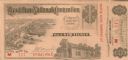
| Description: | Guest ticket for the Republican National Convention held in St. Louis. The ticket shows the celebrated Eads Bridge across the Mississippi, and the log cab... |
| Date: | 1887 |
|---|---|
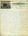
| Description: | Letterhead of the La Crosse Wallis Carriage Co., manufacturers of fine family carriages, showing a view of the factory with the Mississippi River in the ba... |

| Date: | 1852 |
|---|---|
| Description: | Hand-colored maps and a series of geological cross sections of the Mississippi River between the Falls of St. Anthony and the mouth of the Wisconsin River ... |

| Date: | 1870 |
|---|---|
| Description: | A geological survey map of Wisconsin, with hand-colored portions showing the surveys completed from 1873 to 1875. Although the title and legend are in Wel... |

| Date: | 1872 |
|---|---|
| Description: | A series of four hand-colored, geological maps of Wisconsin. Starting from the top of the page, the first map is of a section along the line of the 4th pri... |

| Date: | 1873 |
|---|---|
| Description: | A hand-colored, geological map of the Fox and Wisconsin rivers’ water path from the Mississippi River to the Great Lakes. The map also shows those railroad... |

| Date: | 1849 |
|---|---|
| Description: | Published in Germany a year after Wisconsin entered statehood, this map shows prairies, swamps, lakes, mounds, limestone deposits, and lead and copper mine... |

| Date: | 1874 |
|---|---|
| Description: | A hand-colored, geological map of Wisconsin show the progress of the state geological survey in 1873 and 1874. Other elements displayed in the map include... |
| Date: | 05 24 1820 |
|---|---|
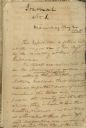
| Description: | A page, headed with "Journal No. 1," of James Doty's journal of a trip with Cass, Schoolcraft, etc. to the sources of the Mississippi River. |
If you didn't find the material you searched for, our Library Reference Staff can help.
Call our reference desk at 608-264-6535 or email us at:
