 Filter: Categories of Wisconsin Historical Images
Filter: Subject of Mississippi River
Filter: Year of 1900-1999
Filter: Year of 1930-1939
Filter: Categories of Wisconsin Historical Images
Filter: Subject of Mississippi River
Filter: Year of 1900-1999
Filter: Year of 1930-1939
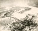
| Date: | 1935 |
|---|---|
| Description: | An aerial view of La Crosse and the Mississippi River with the bridge drawn in to show what the finished product would look like. |
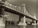
| Date: | 09 1939 |
|---|---|
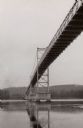
| Description: | View from shoreline towards the bridge over the Mississippi River in La Crosse. |
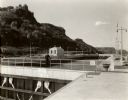
| Date: | 1935 |
|---|---|
| Description: | Locks on the Mississippi River, a nine foot channel. A man is standing above the locks. Bluffs are in the background. |

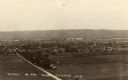
| Date: | 1930 |
|---|---|
| Description: | View of town on opposite shoreline, and piers in the foreground on the right. Taken from the Burlington Railroad bridge. |
| Date: | 1930 |
|---|---|
| Description: | Elevated view of the north side of town, from high on the bluff. Caption reads: "'Birdseye' No. End Prairie Du Chien, Wis." |
| Date: | 1931 |
|---|---|
| Description: | Mississippi River from the Brisbois Mansion. Left to right: Dousman House Hotel, railroad station, electrical plant smokestack, Diamond Jo warehouse, and a... |

| Date: | 1936 |
|---|---|
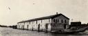
| Description: | Elevated view over the long roof of the Diamond Jo warehouse. The Mississippi River is on the left, with hills in the background. |
| Date: | 1930 |
|---|---|
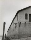
| Description: | View looking up at a corner of the Diamond Jo warehouse. |

| Date: | 1930 |
|---|---|
| Description: | View across railroad tracks towards the Diamond Jo warehouse. A bridge over the Mississippi River is in the background. |
| Date: | 1930 |
|---|---|
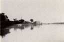
| Description: | View across Mississippi Rover towards the Diamond Jo warehouse along the shoreline. |
| Date: | 1935 |
|---|---|
| Description: | The Highway bridge over the Mississippi River, erected in 1931-1932. View looking west toward Iowa. |
| Date: | 1930 |
|---|---|
| Description: | Elevated view of Perrot State Park (Trempealeau vicinity) looking west from Brady's Bluff toward the Mississippi River and Minnesota. Railroad tracks run a... |

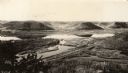
| Date: | 1930 |
|---|---|
| Description: | Aerial view looking east at Mt. Trempealeau from Brady's Bluff in Perrot State Park. The Mississippi River is visible along the bluffs at upper left, and t... |

| Date: | 03 31 1938 |
|---|---|
| Description: | Mississippi River from the bluffs and hills of western Wisconsin, looking south. |

| Date: | 1937 |
|---|---|
| Description: | Official state highway map, with insets of cities. |

| Date: | 1932 |
|---|---|
| Description: | This map includes a distance table, text, and insets maps of, Superior, Ashland, Marinette, Green Bay, Appleton, Manitowoc, Oshkosh, Fond Du Lac, Janesvill... |
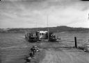
| Date: | 1938 |
|---|---|
| Description: | View from road leading down to shoreline of a Mississippi River ferry bringing several cars across the river. |

| Date: | 1930 |
|---|---|
| Description: | Pen and ink map on paper of Wisconsin and northern Illinois showing stagecoach routes (marked in red) that traveled between Lake Michigan and the Mississip... |

| Date: | 1935 |
|---|---|
| Description: | This map shows Wisconsin’s pinery region. Lake Superior, Lake Michigan, Lake Winnebago, Green Bay, the Wisconsin River, and the Mississippi River are label... |

| Date: | 1931 |
|---|---|
| Description: | This U.S. Geological Survey map of Wisconsin shows counties, cities and villages, lighthouses, Indian reservations, military reservations, and bird and gam... |
If you didn't find the material you searched for, our Library Reference Staff can help.
Call our reference desk at 608-264-6535 or email us at: