 Filter: Categories of Wisconsin Historical Images
Filter: Subject of Mississippi River
Filter: Categories of Wisconsin Historical Images
Filter: Subject of Mississippi River
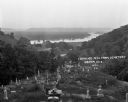
| Date: | 1922 |
|---|---|
| Description: | View from the hilltop at the Genoa cemetery looking down towards the village, the Mississippi River and the Minnesota border. |
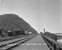
| Date: | 1909 |
|---|---|
| Description: | View along a brick platform towards the Glen Haven depot, where two men stand against the building. Behind the depot is a building with a sign for the "Me... |

| Date: | 1866 |
|---|---|
| Description: | This thematic shows the effects that Lake Michigan has had on Wisconsin mean temperatures in January and July. The map shows counties, some cities, rivers ... |

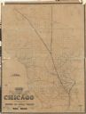
| Date: | 1916 |
|---|---|
| Description: | A pen on paper, hand-drawn map that shows the railroads, rivers, county outlines, and cities and villages in Wisconsin, northern Illinois, and the western ... |

| Date: | 1866 |
|---|---|
| Description: | A pen on paper, hand-drawn and colored map of Wisconsin and Michigan, showing counties, cities and villages, rivers and lakes, as well as railroads are in ... |

| Date: | 1870 |
|---|---|
| Description: | A geological survey map of Wisconsin, with hand-colored portions showing the surveys completed from 1873 to 1875. Although the title and legend are in Wel... |

| Date: | 1872 |
|---|---|
| Description: | A series of four hand-colored, geological maps of Wisconsin. Starting from the top of the page, the first map is of a section along the line of the 4th pri... |

| Date: | 1873 |
|---|---|
| Description: | A hand-colored, geological map of the Fox and Wisconsin rivers’ water path from the Mississippi River to the Great Lakes. The map also shows those railroad... |

| Date: | 1873 |
|---|---|
| Description: | Map of Wisconsin showing counties, county seats, cities with populations over 3,000, and congressional districts. The map also includes rivers, lakes, rail... |
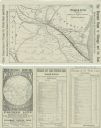
| Date: | 1874 |
|---|---|
| Description: | A folded brochure with a map of the Chicago to Saint Paul rail line through Wisconsin by way of the Chicago & North-Western and West Wisconsin Railways. Th... |

| Date: | 1877 |
|---|---|
| Description: | A map of the triangulation and reconnaissance along the southwest corner of Wisconsin. The map shows the river systems, railroads, cities, and villages tha... |

| Date: | 1925 |
|---|---|
| Description: | A metal bridge from La Crescent over the Mississippi River to La Crosse. |

| Date: | 1838 |
|---|---|
| Description: | This manuscript map, drawn in pencil, shows the lakes and rivers in the area between Lake of the Woods in northern Minnesota, the Mississippi River on the ... |

| Date: | 1849 |
|---|---|
| Description: | Published in Germany a year after Wisconsin entered statehood, this map shows prairies, swamps, lakes, mounds, limestone deposits, and lead and copper mine... |

| Date: | 1854 |
|---|---|
| Description: | This map shows surveyed counties in blue, yellow, and pink, railroads, plank roads and mines. Lake Michigan, the Mississippi River, other rivers and lakes,... |
| Date: | 1855 |
|---|---|
| Description: | A map of Wisconsin and northern Illinois, showing the railroad routes in these areas, specifically the Fox River Valley, Wisconsin Central and the Ontonago... |

| Date: | 1855 |
|---|---|
| Description: | This map shows the entire state and part of the Upper Peninsula of Michigan. It depicts creeks, rivers, lakes, railroads completed, railroads in progress, ... |

| Date: | 1874 |
|---|---|
| Description: | A hand-colored, geological map of Wisconsin show the progress of the state geological survey in 1873 and 1874. Other elements displayed in the map include... |
| Date: | 05 24 1820 |
|---|---|
| Description: | A page, headed with "Journal No. 1," of James Doty's journal of a trip with Cass, Schoolcraft, etc. to the sources of the Mississippi River. |
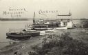
| Date: | |
|---|---|
| Description: | Postcard labeled in photographer's hand: "Souvinr [sic] Mississippi River, Cassville." A Frank Feiker 'Souvenir' postcard of several excusion boats on the ... |
If you didn't find the material you searched for, our Library Reference Staff can help.
Call our reference desk at 608-264-6535 or email us at: