 Filter: Categories of Wisconsin Historical Images
Filter: Subject of Mounds
Filter: Subject of indians of north america
Filter: Categories of Wisconsin Historical Images
Filter: Subject of Mounds
Filter: Subject of indians of north america

| Date: | 10 07 1914 |
|---|---|
| Description: | Sara (Mrs. Joseph) Mallon (Menominee) of Milwaukee, wearing a sash stands between two American flags behind a memorial that reads, "Indian Mounds: One of s... |

| Date: | |
|---|---|
| Description: | Wisconsin Memorial Hospital with a key to buildings in the upper left. Indian mounds are marked on the site. Arthur Peabody was the state architect for th... |
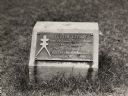
| Date: | 1930 |
|---|---|
| Description: | Turtle Effigy mound marker on the University of Wisconsin-Madison campus. There is a metal plaque on a small formed block. An image of the mound is on the ... |
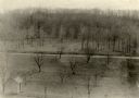
| Date: | |
|---|---|
| Description: | Elevated view of Man Mound outlined in chalk looking south. A road bisects the legs of the effigy mound. A small outbuilding can be seen at left in the for... |
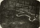
| Date: | |
|---|---|
| Description: | Elevated view of bear effigy mound outlined in chalk at Lake Koshkonong. |
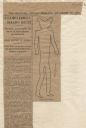
| Date: | 12 28 1906 |
|---|---|
| Description: | Newspaper article about the purchase of land for a park related to Man Mound in Sauk County accompanied by a line drawing of the mound. Article clipped fro... |

| Date: | 1927 |
|---|---|
| Description: | Blueprint-style map of Frost Woods on the shore of Lake Monona. The map indicates the locations of Indian mounds, an Indian camp, and various plants. There... |

| Date: | 04 12 1912 |
|---|---|
| Description: | Diagram of a bird effigy mound found in Frost's Woods, Blooming Grove Township. |

| Date: | |
|---|---|
| Description: | Map of prehistoric mounds near the Big Kanawha River. |

| Date: | |
|---|---|
| Description: | Ink and watercolor of prehistoric mounds near the mouth of Haigs Creek and the Scioto River. |

| Date: | 1851 |
|---|---|
| Description: | Diagram of an effigy mound in the shape of a cross. |

| Date: | 1851 |
|---|---|
| Description: | Map of a portion of Merton including the Bark River, a mill, Fort Hill, and Indian mounds. |

| Date: | 1916 |
|---|---|
| Description: | In 1916, it was estimated that 15,000 Indian mounds had formerly existed in Wisconsin. In the early 20th century, the Wisconsin Archaeological Society surv... |

| Date: | 1872 |
|---|---|
| Description: | This map, which includes eastern Iowa, northern Illinois and a portion of Michigan's Upper peninsula, shows the township survey grid and identifies countie... |

| Date: | 1921 |
|---|---|
| Description: | A man sits on top of a mound near Trade Lake. |

| Date: | 1921 |
|---|---|
| Description: | Three men and four children standing on top of a mound near Round Lake. |

| Date: | 1927 |
|---|---|
| Description: | Three men and two women sit on top of a mound near Trade Lake. |

| Date: | 01 01 1852 |
|---|---|
| Description: | These manuscript maps, drawn by William H. Canfield in 1852, illustrate mounds primarily in Sauk County, Wisconsin, in the towns of Greenfield, La Valle, M... |

| Date: | 1941 |
|---|---|
| Description: | This pictorial map shows sites related to Indian legends, mounds, and trails in the Chain O' Lakes region in southwestern Waupaca County, Wisconsin. |
If you didn't find the material you searched for, our Library Reference Staff can help.
Call our reference desk at 608-264-6535 or email us at:
